Cootehill geodata
Cootehill (Ulster) is a populated place; located in Ireland in Europe/Dublin (GMT+1) time zone. With population of 1,713 people, there are 252 cities with bigger population in this country. Compared to other cities in Ireland, 89.2% of cities are located further ↓South; 56.9% of cities are located further ←West and 85% of cities have lower elevation than Cootehill. Note1


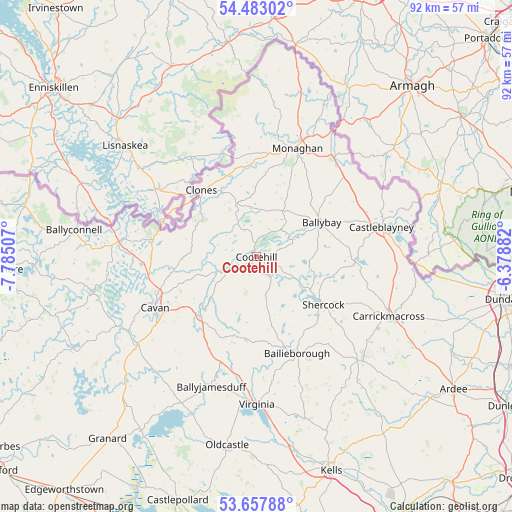
Cootehill GPS coordinates[2]
54° 4' 21" North, 7° 4' 54.984" West
| Map corner | latitude | longitude |
|---|---|---|
| Upper-left | 54.48302°, | -7.78507° |
| Center: | 54.0725°, | -7.08194° |
| Lower-right: | 53.65788°, | -6.37882° |
| Map W x H: | 91.7×91.7 km | = 57×57mi |
| max Lat: | 55.25° ⇑10.8% North |
| Cootehill: | 54.0725° |
| min Lat: | ⇓89.2% South 51.52487° |
| min Long | Cootehill | max Long |
| -10.26889° | -7.08194° | -6.04944° |
| W 56.9%⇐ | ⇒43.1% E |
Elevation
Elevation of Cootehill is 96 m = 315 ft, and this is 41.5 m = 136 ft above average elevation for this country.
| Max E: |
262 m = 860 ft | 15% |
| Cootehill | 96 m 315 ft | |
| Avg. | 54.5 m = 179 ft | |
Min E: |
0 m = 0 ft | 85% |
See also: Ireland elevation on elevation.city.
Geographical zone
Cootehill is located in North temperate zone (between Tropic of Cancer and the Arctic Circle). Distance of this North polar circle is 1388.9 km =863 mi to North.| Distance of | km | miles | from Cootehill |
|---|---|---|---|
| North Pole | 3994.8 | 2482.3 | to North |
| Arctic Circle | 1388.9 | 863 | to North |
| Tropic Cancer | 3406.4 | 2116.6 | to South |
| Equator | 6012.3 | 3735.9 | to South |


Nearby cities:
15 places around Cootehill: (largest is in red/bold)
• Bailieborough
18.9 km =11.7 mi,  156°
156°
• Ballinagh
26.8 km =16.7 mi,  234°
234°
• Ballyhaise
15.5 km =9.6 mi,  260°
260°
• Ballyjamesduff
24.4 km =15.2 mi,  198°
198°
• Belturbet
24.2 km =15 mi,  277°
277°
• Carrickmacross
26.2 km =16.3 mi,  115°
115°
• Castleblayney
23.3 km =14.5 mi,  77°
77°
• Cavan
20.3 km =12.6 mi,  243°
243°
• Clones
15.8 km =9.8 mi,  321°
321°
• Emyvale
30.9 km =19.2 mi,  14°
14°
• Kingscourt
25.7 km =16 mi,  135°
135°
• Monaghan
21.1 km =13.1 mi,  20°
20°
• Mullagh
30.1 km =18.7 mi, 163°
• Shercock
14.4 km =8.9 mi, 124°
• Virginia
26.5 km =16.5 mi,  179°
179°
Sources, notices
• [Note1] Compared only with cities in Ireland existing in our database
• [Src1] Map data: © OpenStreetMap contributors (CC-BY-SA)
• [Src2] Other city data from geonames.org with taken over terms of usage.
• [Src3] Geographical zone / Annual Mean Temperature by Robert A. Rohde @ Wikipedia
