Qiryat Shemona geodata
Qiryat Shemona (Northern District) is a populated place; located in Israel in Asia/Jerusalem (GMT+3) time zone. With population of 22,035 people, there are 60 cities with bigger population in this country. Compared to other cities in Israel, 99.4% of cities are located further ↓South; 97% of cities are located further ←West and 52.1% of cities have lower elevation than Qiryat Shemona. Note1


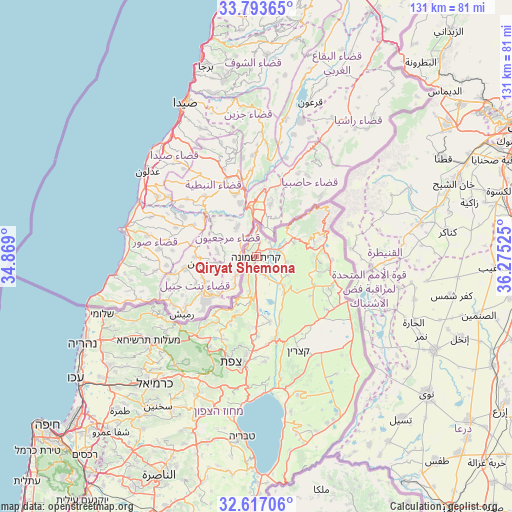
Qiryat Shemona GPS coordinates[2]
33° 12' 26.388" North, 35° 34' 19.632" East
| Map corner | latitude | longitude |
|---|---|---|
| Upper-left | 33.79365°, | 34.869° |
| Center: | 33.20733°, | 35.57212° |
| Lower-right: | 32.61706°, | 36.27525° |
| Map W x H: | 130.8×130.8 km | = 81.3×81.3mi |
| max Lat: | 33.27918° ⇑0.6% North |
| Qiryat Shemona: | 33.20733° |
| min Lat: | ⇓99.4% South 29.55805° |
| min Long | Qiryat Shemona | max Long |
| 34.57149° | 35.57212° | 35.81084° |
| W 97%⇐ | ⇒3% E |
Elevation
Elevation of Qiryat Shemona is 124 m = 407 ft, and this is 99.4 m = 326 ft below average elevation for this country.
| Max E: |
988 m = 3241 ft | 47.9% |
| Avg. | 223.4 m = 733 ft | |
| Qiryat Shemona | 124 m = 407 ft | |
Min E: |
-380 m = -1247 ft | 52.1% |
See also: Israel elevation on elevation.city.
Geographical zone
Qiryat Shemona is located in North temperate zone (between Tropic of Cancer and the Arctic Circle). Distance of this Northern Tropic circle is 1086.4 km =675.1 mi to South.| Distance of | km | miles | from Qiryat Shemona |
|---|---|---|---|
| North Pole | 6314.8 | 3923.8 | to North |
| Arctic Circle | 3708.9 | 2304.6 | to North |
| Tropic Cancer | 1086.4 | 675.1 | to South |
| Equator | 3692.3 | 2294.3 | to South |


Nearby cities:
15 places around Qiryat Shemona: (largest is in red/bold)
• Al Buţayḩah
33.7 km =20.9 mi,  170°
170°
• Al Khushnīyah
32.1 km =19.9 mi,  136°
136°
• Beit Jann
32.3 km =20.1 mi,  213°
213°
• Buqei‘a
33.9 km =21.1 mi,  221°
221°
• Jīsh
23.7 km =14.7 mi, 209°
• Kefar Weradim
36.3 km =22.6 mi,  229°
229°
• Metulla
8 km =5 mi,  4°
4°
• Mi‘ilyā
35.5 km =22.1 mi,  235°
235°
• Mārom Golan
20.8 km =12.9 mi,  113°
113°
• Pasuta
30.2 km =18.8 mi, 234°
• Rosh Pinna
26.6 km =16.5 mi,  185°
185°
• Safed
27.9 km =17.3 mi, 194°
• Sājūr
36.4 km =22.6 mi, 216°
• maalot Tarshīhā
35.5 km =22.1 mi, 233°
• Ḥurfeish
29.7 km =18.5 mi, 224°
Sources, notices
• [Note1] Compared only with cities in Israel existing in our database
• [Src1] Map data: © OpenStreetMap contributors (CC-BY-SA)
• [Src2] Other city data from geonames.org with taken over terms of usage.
• [Src3] Geographical zone / Annual Mean Temperature by Robert A. Rohde @ Wikipedia
