Metulla geodata
Metulla (Northern District) is a populated place; located in Israel in Asia/Jerusalem (GMT+3) time zone. With population of 1,466 people, there are 149 cities with bigger population in this country. Compared to other cities in Israel, 100% of cities are located further ↓South; 97.6% of cities are located further ←West and 84% of cities have lower elevation than Metulla. Note1


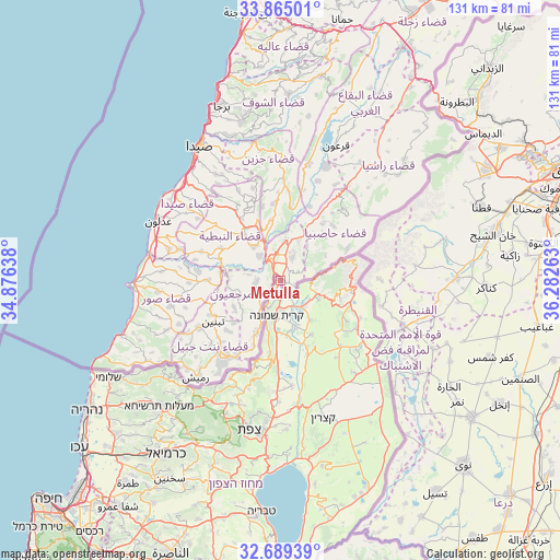
Metulla GPS coordinates[2]
33° 16' 45.048" North, 35° 34' 46.2" East
| Map corner | latitude | longitude |
|---|---|---|
| Upper-left | 33.86501°, | 34.87638° |
| Center: | 33.27918°, | 35.5795° |
| Lower-right: | 32.68939°, | 36.28263° |
| Map W x H: | 130.7×130.7 km | = 81.2×81.2mi |
| max Lat: | 33.27918° ⇑0% North |
| Metulla: | 33.27918° |
| min Lat: | ⇓100% South 29.55805° |
| min Long | Metulla | max Long |
| 34.57149° | 35.5795° | 35.81084° |
| W 97.6%⇐ | ⇒2.4% E |
Elevation
Elevation of Metulla is 525 m = 1722 ft, and this is 301.6 m = 990 ft above average elevation for this country.
| Max E: |
988 m = 3241 ft | 16% |
| Metulla | 525 m 1722 ft | |
| Avg. | 223.4 m = 733 ft | |
Min E: |
-380 m = -1247 ft | 84% |
See also: Israel elevation on elevation.city.
Geographical zone
Metulla is located in North temperate zone (between Tropic of Cancer and the Arctic Circle). Distance of this Northern Tropic circle is 1094.4 km =680 mi to South.| Distance of | km | miles | from Metulla |
|---|---|---|---|
| North Pole | 6306.8 | 3918.9 | to North |
| Arctic Circle | 3700.9 | 2299.6 | to North |
| Tropic Cancer | 1094.4 | 680 | to South |
| Equator | 3700.3 | 2299.3 | to South |


Nearby cities:
15 places around Metulla: (largest is in red/bold)
• Al Buţayḩah
41.5 km =25.8 mi,  173°
173°
• Al Khushnīyah
37.8 km =23.5 mi,  145°
145°
• Beit Jann
39.5 km =24.5 mi,  207°
207°
• Buqei‘a
40.6 km =25.2 mi, 214°
• Jīsh
31.1 km =19.3 mi,  203°
203°
• Kefar Weradim
42.4 km =26.3 mi,  221°
221°
• Mi‘ilyā
41 km =25.5 mi,  227°
227°
• Mārom Golan
24.6 km =15.3 mi,  131°
131°
• Pasuta
35.9 km =22.3 mi, 224°
• Qiryat Shemona
8 km =5 mi,  184°
184°
• Rosh Pinna
34.7 km =21.6 mi,  185°
185°
• Safed
35.8 km =22.2 mi, 192°
• Sājūr
43.5 km =27 mi, 210°
• maalot Tarshīhā
41.2 km =25.6 mi, 224°
• Ḥurfeish
36.2 km =22.5 mi, 216°
Sources, notices
• [Note1] Compared only with cities in Israel existing in our database
• [Src1] Map data: © OpenStreetMap contributors (CC-BY-SA)
• [Src2] Other city data from geonames.org with taken over terms of usage.
• [Src3] Geographical zone / Annual Mean Temperature by Robert A. Rohde @ Wikipedia
