Parwanoo geodata
Parwanoo (Himachal Pradesh) is a populated place; located in India in Asia/Kolkata (GMT+5.5) time zone. With population of 8,609 people, there are 3070 cities with bigger population in this country. Compared to other cities in India, 95.3% of cities are located further ↓South; 63.6% of cities are located further →East and 93.8% of cities have lower elevation than Parwanoo. Note1


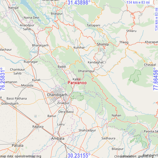
Parwanoo GPS coordinates[2]
30° 50' 13.776" North, 76° 57' 41.148" East
| Map corner | latitude | longitude |
|---|---|---|
| Upper-left | 31.43898°, | 76.25831° |
| Center: | 30.83716°, | 76.96143° |
| Lower-right: | 30.23155°, | 77.66456° |
| Map W x H: | 134.3×134.3 km | = 83.5×83.5mi |
| max Lat: | 34.9274° ⇑4.7% North |
| Parwanoo: | 30.83716° |
| min Lat: | ⇓95.3% South 8.09008° |
| min Long | Parwanoo | max Long |
| 68.82655° | 76.96143° | 96.81° |
| W 36.4%⇐ | ⇒63.6% E |
Elevation
Elevation of Parwanoo is 789 m = 2589 ft, and this is 493.4 m = 1619 ft above average elevation for this country.
| Max E: |
3681 m = 12077 ft | 6.2% |
| Parwanoo | 789 m 2589 ft | |
| Avg. | 295.6 m = 970 ft | |
Min E: |
1 m = 3 ft | 93.8% |
See also: India elevation on elevation.city.
Geographical zone
Parwanoo is located in North temperate zone (between Tropic of Cancer and the Arctic Circle). Distance of this Northern Tropic circle is 822.9 km =511.3 mi to South.| Distance of | km | miles | from Parwanoo |
|---|---|---|---|
| North Pole | 6578.3 | 4087.6 | to North |
| Arctic Circle | 3972.4 | 2468.3 | to North |
| Tropic Cancer | 822.9 | 511.3 | to South |
| Equator | 3428.8 | 2130.6 | to South |


Nearby cities:
15 places around Parwanoo: (largest is in red/bold)
• Baddi
21.1 km =13.1 mi,  309°
309°
• Basi
29.8 km =18.5 mi,  201°
201°
• Chandigarh
20 km =12.4 mi,  235°
235°
• Dagshai
10.1 km =6.3 mi,  58°
58°
• Jutogh
32.8 km =20.4 mi,  26°
26°
• Kasauli
6.8 km =4.2 mi,  3°
3°
• Kharar
31.7 km =19.7 mi,  251°
251°
• Kālka
2 km =1.2 mi,  278°
278°
• Mohali
28.8 km =17.9 mi,  232°
232°
• Nālāgarh
32.2 km =20 mi, 314°
• Panchkula
19.1 km =11.9 mi,  213°
213°
• Pinjaur
5.9 km =3.7 mi,  223°
223°
• Rājgarh
32.4 km =20.1 mi,  87°
87°
• Sabāthu
15.6 km =9.7 mi,  10°
10°
• Solan
16.2 km =10.1 mi, 60°
Sources, notices
• [Note1] Compared only with cities in India existing in our database
• [Src1] Map data: © OpenStreetMap contributors (CC-BY-SA)
• [Src2] Other city data from geonames.org with taken over terms of usage.
• [Src3] Geographical zone / Annual Mean Temperature by Robert A. Rohde @ Wikipedia
