Pinjaur geodata
Pinjaur (Haryana) is a populated place; located in India in Asia/Kolkata (GMT+5.5) time zone. With population of 32,162 people, there are 1351 cities with bigger population in this country. Compared to other cities in India, 95.1% of cities are located further ↓South; 64.2% of cities are located further →East and 85.6% of cities have lower elevation than Pinjaur. Note1


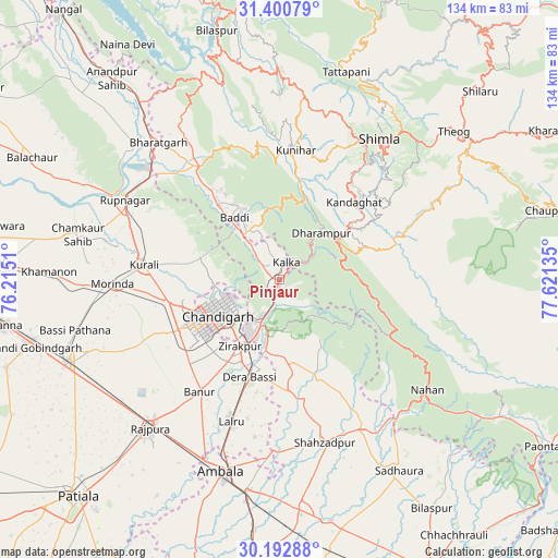
Pinjaur GPS coordinates[2]
30° 47' 55.428" North, 76° 55' 5.592" East
| Map corner | latitude | longitude |
|---|---|---|
| Upper-left | 31.40079°, | 76.2151° |
| Center: | 30.79873°, | 76.91822° |
| Lower-right: | 30.19288°, | 77.62135° |
| Map W x H: | 134.3×134.3 km | = 83.5×83.5mi |
| max Lat: | 34.9274° ⇑4.9% North |
| Pinjaur: | 30.79873° |
| min Lat: | ⇓95.1% South 8.09008° |
| min Long | Pinjaur | max Long |
| 68.82655° | 76.91822° | 96.81° |
| W 35.8%⇐ | ⇒64.2% E |
Elevation
Elevation of Pinjaur is 558 m = 1831 ft, and this is 262.4 m = 861 ft above average elevation for this country.
| Max E: |
3681 m = 12077 ft | 14.4% |
| Pinjaur | 558 m 1831 ft | |
| Avg. | 295.6 m = 970 ft | |
Min E: |
1 m = 3 ft | 85.6% |
See also: India elevation on elevation.city.
Geographical zone
Pinjaur is located in North temperate zone (between Tropic of Cancer and the Arctic Circle). Distance of this Northern Tropic circle is 818.6 km =508.7 mi to South.| Distance of | km | miles | from Pinjaur |
|---|---|---|---|
| North Pole | 6582.6 | 4090.2 | to North |
| Arctic Circle | 3976.7 | 2471 | to North |
| Tropic Cancer | 818.6 | 508.7 | to South |
| Equator | 3424.5 | 2127.9 | to South |


Nearby cities:
15 places around Pinjaur: (largest is in red/bold)
• Baddi
21.4 km =13.3 mi,  325°
325°
• Banūr
33.2 km =20.6 mi,  214°
214°
• Basi
24.4 km =15.2 mi,  196°
196°
• Chandigarh
14.2 km =8.8 mi,  240°
240°
• Dagshai
15.9 km =9.9 mi,  53°
53°
• Kasauli
12 km =7.5 mi,  22°
22°
• Kharar
26.6 km =16.5 mi,  257°
257°
• Kālka
5 km =3.1 mi,  25°
25°
• Mohali
22.9 km =14.2 mi,  234°
234°
• Nālāgarh
32.8 km =20.4 mi, 325°
• Panchkula
13.3 km =8.3 mi, 209°
• Parwanoo
5.9 km =3.7 mi,  43°
43°
• Rājgarh
37 km =23 mi,  80°
80°
• Sabāthu
20.8 km =12.9 mi, 19°
• Solan
21.9 km =13.6 mi,  55°
55°
Sources, notices
• [Note1] Compared only with cities in India existing in our database
• [Src1] Map data: © OpenStreetMap contributors (CC-BY-SA)
• [Src2] Other city data from geonames.org with taken over terms of usage.
• [Src3] Geographical zone / Annual Mean Temperature by Robert A. Rohde @ Wikipedia
