Baddi geodata
Baddi (Himachal Pradesh) is a populated place; located in India in Asia/Kolkata (GMT+5.5) time zone. With population of 22,592 people, there are 1868 cities with bigger population in this country. Compared to other cities in India, 95.6% of cities are located further ↓South; 65.2% of cities are located further →East and 77.7% of cities have lower elevation than Baddi. Note1


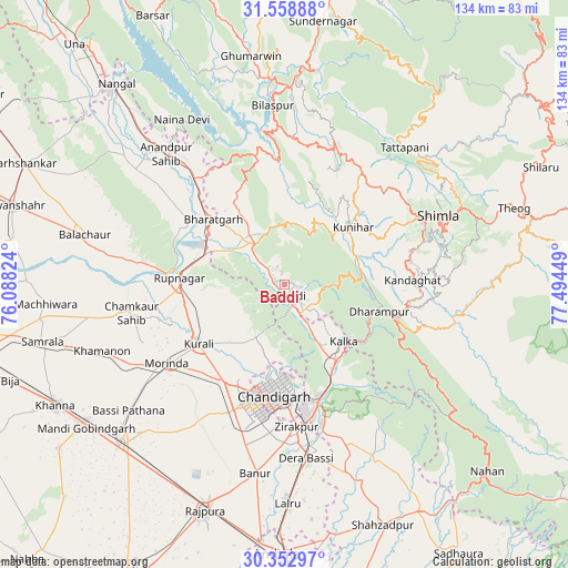
Baddi GPS coordinates[2]
30° 57' 28.188" North, 76° 47' 28.896" East
| Map corner | latitude | longitude |
|---|---|---|
| Upper-left | 31.55888°, | 76.08824° |
| Center: | 30.95783°, | 76.79136° |
| Lower-right: | 30.35297°, | 77.49449° |
| Map W x H: | 134.1×134.1 km | = 83.3×83.3mi |
| max Lat: | 34.9274° ⇑4.4% North |
| Baddi: | 30.95783° |
| min Lat: | ⇓95.6% South 8.09008° |
| min Long | Baddi | max Long |
| 68.82655° | 76.79136° | 96.81° |
| W 34.8%⇐ | ⇒65.2% E |
Elevation
Elevation of Baddi is 426 m = 1398 ft, and this is 130.4 m = 428 ft above average elevation for this country.
| Max E: |
3681 m = 12077 ft | 22.3% |
| Baddi | 426 m 1398 ft | |
| Avg. | 295.6 m = 970 ft | |
Min E: |
1 m = 3 ft | 77.7% |
See also: India elevation on elevation.city.
Geographical zone
Baddi is located in North temperate zone (between Tropic of Cancer and the Arctic Circle). Distance of this Northern Tropic circle is 836.3 km =519.7 mi to South.| Distance of | km | miles | from Baddi |
|---|---|---|---|
| North Pole | 6564.9 | 4079.2 | to North |
| Arctic Circle | 3959 | 2460 | to North |
| Tropic Cancer | 836.3 | 519.7 | to South |
| Equator | 3442.2 | 2138.9 | to South |


Nearby cities:
15 places around Baddi: (largest is in red/bold)
• Arki
27.3 km =17 mi,  37°
37°
• Chandigarh
24.6 km =15.3 mi,  180°
180°
• Dagshai
26.2 km =16.3 mi,  108°
108°
• Kasauli
17.9 km =11.1 mi, 111°
• Kharar
27.3 km =17 mi,  210°
210°
• Kālka
19.4 km =12.1 mi,  132°
132°
• Mohali
31.6 km =19.6 mi,  192°
192°
• Morinda
33.6 km =20.9 mi,  236°
236°
• Nālāgarh
11.4 km =7.1 mi,  324°
324°
• Panchkula
29.8 km =18.5 mi,  169°
169°
• Parwanoo
21.1 km =13.1 mi, 129°
• Pinjaur
21.4 km =13.3 mi,  145°
145°
• Ropar
25.2 km =15.7 mi,  272°
272°
• Sabāthu
19.2 km =11.9 mi,  84°
84°
• Solan
30.7 km =19.1 mi,  100°
100°
Sources, notices
• [Note1] Compared only with cities in India existing in our database
• [Src1] Map data: © OpenStreetMap contributors (CC-BY-SA)
• [Src2] Other city data from geonames.org with taken over terms of usage.
• [Src3] Geographical zone / Annual Mean Temperature by Robert A. Rohde @ Wikipedia
