Ambāla geodata
Ambāla (Haryana) is a populated place; located in India in Asia/Kolkata (GMT+5.5) time zone. With population of 146,787 people, there are 299 cities with bigger population in this country. Compared to other cities in India, 93.9% of cities are located further ↓South; 65.1% of cities are located further →East and 63.7% of cities have lower elevation than Ambāla. Note1


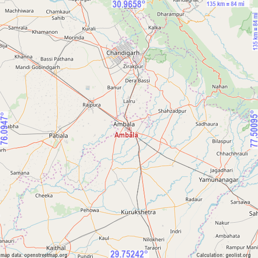
Ambāla GPS coordinates[2]
30° 21' 39.564" North, 76° 47' 52.152" East
| Map corner | latitude | longitude |
|---|---|---|
| Upper-left | 30.9658°, | 76.0947° |
| Center: | 30.36099°, | 76.79782° |
| Lower-right: | 29.75242°, | 77.50095° |
| Map W x H: | 134.9×134.9 km | = 83.8×83.8mi |
| max Lat: | 34.9274° ⇑6.1% North |
| Ambāla: | 30.36099° |
| min Lat: | ⇓93.9% South 8.09008° |
| min Long | Ambāla | max Long |
| 68.82655° | 76.79782° | 96.81° |
| W 34.9%⇐ | ⇒65.1% E |
Elevation
Elevation of Ambāla is 276 m = 906 ft, and this is 19.6 m = 64 ft below average elevation for this country.
| Max E: |
3681 m = 12077 ft | 36.3% |
| Avg. | 295.6 m = 970 ft | |
| Ambāla | 276 m = 906 ft | |
Min E: |
1 m = 3 ft | 63.7% |
See also: Ambāla elevation on elevation.city.
Geographical zone
Ambāla is located in North temperate zone (between Tropic of Cancer and the Arctic Circle). Distance of this Northern Tropic circle is 769.9 km =478.4 mi to South.| Distance of | km | miles | from Ambāla |
|---|---|---|---|
| North Pole | 6631.2 | 4120.4 | to North |
| Arctic Circle | 4025.3 | 2501.2 | to North |
| Tropic Cancer | 769.9 | 478.4 | to South |
| Equator | 3375.8 | 2097.6 | to South |


Nearby cities:
15 places around Ambāla: (largest is in red/bold)
• Banūr
22.7 km =14.1 mi,  340°
340°
• Basi
25.7 km =16 mi,  10°
10°
• Chandigarh
41.7 km =25.9 mi,  358°
358°
• Ghanaur
18.1 km =11.2 mi,  259°
259°
• Kharar
45.2 km =28.1 mi, 341°
• Lādwa
47.3 km =29.4 mi,  149°
149°
• Mohali
36.2 km =22.5 mi,  348°
348°
• Mustafābād
38 km =23.6 mi,  117°
117°
• Narāyangarh
34.2 km =21.3 mi,  67°
67°
• Panchkula
37.4 km =23.2 mi, 7°
• Patiāla
39 km =24.2 mi,  265°
265°
• Rājpura
23.6 km =14.7 mi,  303°
303°
• Sanaur
33.3 km =20.7 mi, 258°
• Shāhābād
22.6 km =14 mi,  162°
162°
• Thānesar
43.2 km =26.8 mi,  175°
175°
Sources, notices
• [Note1] Compared only with cities in India existing in our database
• [Src1] Map data: © OpenStreetMap contributors (CC-BY-SA)
• [Src2] Other city data from geonames.org with taken over terms of usage.
• [Src3] Geographical zone / Annual Mean Temperature by Robert A. Rohde @ Wikipedia
