Arki geodata
Arki (Himachal Pradesh) is a populated place; located in India in Asia/Kolkata (GMT+5.5) time zone. With population of 3,293 people, there are 3403 cities with bigger population in this country. Compared to other cities in India, 96.2% of cities are located further ↓South; 63.4% of cities are located further →East and 96.6% of cities have lower elevation than Arki. Note1


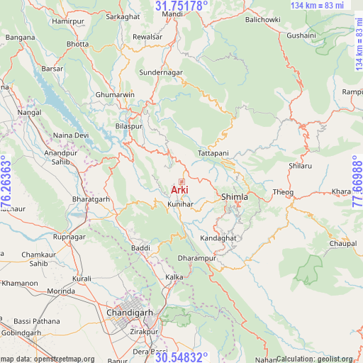
Arki GPS coordinates[2]
31° 9' 7.056" North, 76° 58' 0.3" East
| Map corner | latitude | longitude |
|---|---|---|
| Upper-left | 31.75178°, | 76.26363° |
| Center: | 31.15196°, | 76.96675° |
| Lower-right: | 30.54832°, | 77.66988° |
| Map W x H: | 133.8×133.8 km | = 83.1×83.1mi |
| max Lat: | 34.9274° ⇑3.8% North |
| Arki: | 31.15196° |
| min Lat: | ⇓96.2% South 8.09008° |
| min Long | Arki | max Long |
| 68.82655° | 76.96675° | 96.81° |
| W 36.6%⇐ | ⇒63.4% E |
Elevation
Elevation of Arki is 1126 m = 3694 ft, and this is 830.4 m = 2724 ft above average elevation for this country.
| Max E: |
3681 m = 12077 ft | 3.4% |
| Arki | 1126 m 3694 ft | |
| Avg. | 295.6 m = 970 ft | |
Min E: |
1 m = 3 ft | 96.6% |
See also: India elevation on elevation.city.
Geographical zone
Arki is located in North temperate zone (between Tropic of Cancer and the Arctic Circle). Distance of this Northern Tropic circle is 857.9 km =533.1 mi to South.| Distance of | km | miles | from Arki |
|---|---|---|---|
| North Pole | 6543.3 | 4065.8 | to North |
| Arctic Circle | 3937.4 | 2446.6 | to North |
| Tropic Cancer | 857.9 | 533.1 | to South |
| Equator | 3463.8 | 2152.3 | to South |


Nearby cities:
15 places around Arki: (largest is in red/bold)
• Baddi
27.3 km =17 mi,  217°
217°
• Bilaspur
28.1 km =17.5 mi,  314°
314°
• Dagshai
30.9 km =19.2 mi,  164°
164°
• Ghumārwīn
40.1 km =24.9 mi,  323°
323°
• Jutogh
15.4 km =9.6 mi,  112°
112°
• Kasauli
28.2 km =17.5 mi,  180°
180°
• Kālka
34.8 km =21.6 mi, 184°
• Nālāgarh
26.3 km =16.3 mi,  242°
242°
• Parwanoo
35 km =21.7 mi, 180°
• Pinjaur
39.5 km =24.5 mi,  186°
186°
• Sabāthu
19.8 km =12.3 mi,  173°
173°
• Seoni
18 km =11.2 mi,  56°
56°
• Shimla
19.7 km =12.2 mi, 105°
• Solan
30.2 km =18.8 mi,  153°
153°
• Theog
37.4 km =23.2 mi,  95°
95°
Sources, notices
• [Note1] Compared only with cities in India existing in our database
• [Src1] Map data: © OpenStreetMap contributors (CC-BY-SA)
• [Src2] Other city data from geonames.org with taken over terms of usage.
• [Src3] Geographical zone / Annual Mean Temperature by Robert A. Rohde @ Wikipedia
