Solan geodata
Solan (Himachal Pradesh) is a populated place; located in India in Asia/Kolkata (GMT+5.5) time zone. With population of 40,283 people, there are 1092 cities with bigger population in this country. Compared to other cities in India, 95.5% of cities are located further ↓South; 61.9% of cities are located further →East and 97.8% of cities have lower elevation than Solan. Note1


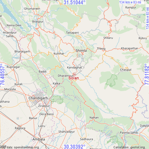
Solan GPS coordinates[2]
30° 54' 32.688" North, 77° 6' 31.284" East
| Map corner | latitude | longitude |
|---|---|---|
| Upper-left | 31.51044°, | 76.40557° |
| Center: | 30.90908°, | 77.10869° |
| Lower-right: | 30.30392°, | 77.81182° |
| Map W x H: | 134.2×134.2 km | = 83.4×83.4mi |
| max Lat: | 34.9274° ⇑4.5% North |
| Solan: | 30.90908° |
| min Lat: | ⇓95.5% South 8.09008° |
| min Long | Solan | max Long |
| 68.82655° | 77.10869° | 96.81° |
| W 38.1%⇐ | ⇒61.9% E |
Elevation
Elevation of Solan is 1509 m = 4951 ft, and this is 1213.4 m = 3981 ft above average elevation for this country.
| Max E: |
3681 m = 12077 ft | 2.2% |
| Solan | 1509 m 4951 ft | |
| Avg. | 295.6 m = 970 ft | |
Min E: |
1 m = 3 ft | 97.8% |
See also: Solan elevation on elevation.city.
Geographical zone
Solan is located in North temperate zone (between Tropic of Cancer and the Arctic Circle). Distance of this Northern Tropic circle is 830.8 km =516.2 mi to South.| Distance of | km | miles | from Solan |
|---|---|---|---|
| North Pole | 6570.3 | 4082.6 | to North |
| Arctic Circle | 3964.4 | 2463.4 | to North |
| Tropic Cancer | 830.8 | 516.2 | to South |
| Equator | 3436.8 | 2135.5 | to South |


Nearby cities:
15 places around Solan: (largest is in red/bold)
• Arki
30.2 km =18.8 mi,  333°
333°
• Baddi
30.7 km =19.1 mi,  280°
280°
• Chandigarh
36.1 km =22.4 mi,  237°
237°
• Dagshai
6 km =3.7 mi, 242°
• Jutogh
21.2 km =13.2 mi,  2°
2°
• Kasauli
13.7 km =8.5 mi,  265°
265°
• Kālka
17.8 km =11.1 mi, 244°
• Panchkula
34.3 km =21.3 mi,  225°
225°
• Parwanoo
16.2 km =10.1 mi, 240°
• Pinjaur
21.9 km =13.6 mi, 235°
• Rājgarh
19.4 km =12.1 mi,  109°
109°
• Sabāthu
13.4 km =8.3 mi,  303°
303°
• Seoni
37 km =23 mi, 2°
• Shimla
22.4 km =13.9 mi,  14°
14°
• Theog
33.5 km =20.8 mi,  45°
45°
Sources, notices
• [Note1] Compared only with cities in India existing in our database
• [Src1] Map data: © OpenStreetMap contributors (CC-BY-SA)
• [Src2] Other city data from geonames.org with taken over terms of usage.
• [Src3] Geographical zone / Annual Mean Temperature by Robert A. Rohde @ Wikipedia
