Sabāthu geodata
Sabāthu (Himachal Pradesh) is a populated place; located in India in Asia/Kolkata (GMT+5.5) time zone. With population of 6,691 people, there are 3234 cities with bigger population in this country. Compared to other cities in India, 95.7% of cities are located further ↓South; 63.2% of cities are located further →East and 96.9% of cities have lower elevation than Sabāthu. Note1


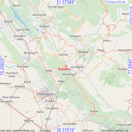
Sabāthu GPS coordinates[2]
30° 58' 29.784" North, 76° 59' 28.932" East
| Map corner | latitude | longitude |
|---|---|---|
| Upper-left | 31.57588°, | 76.28825° |
| Center: | 30.97494°, | 76.99137° |
| Lower-right: | 30.37019°, | 77.6945° |
| Map W x H: | 134.1×134.1 km | = 83.3×83.3mi |
| max Lat: | 34.9274° ⇑4.3% North |
| Sabāthu: | 30.97494° |
| min Lat: | ⇓95.7% South 8.09008° |
| min Long | Sabāthu | max Long |
| 68.82655° | 76.99137° | 96.81° |
| W 36.8%⇐ | ⇒63.2% E |
Elevation
Elevation of Sabāthu is 1235 m = 4052 ft, and this is 939.4 m = 3082 ft above average elevation for this country.
| Max E: |
3681 m = 12077 ft | 3.1% |
| Sabāthu | 1235 m 4052 ft | |
| Avg. | 295.6 m = 970 ft | |
Min E: |
1 m = 3 ft | 96.9% |
See also: India elevation on elevation.city.
Geographical zone
Sabāthu is located in North temperate zone (between Tropic of Cancer and the Arctic Circle). Distance of this Northern Tropic circle is 838.2 km =520.8 mi to South.| Distance of | km | miles | from Sabāthu |
|---|---|---|---|
| North Pole | 6563 | 4078.1 | to North |
| Arctic Circle | 3957.1 | 2458.8 | to North |
| Tropic Cancer | 838.2 | 520.8 | to South |
| Equator | 3444.1 | 2140.1 | to South |


Nearby cities:
15 places around Sabāthu: (largest is in red/bold)
• Arki
19.8 km =12.3 mi,  353°
353°
• Baddi
19.2 km =11.9 mi,  264°
264°
• Chandigarh
32.9 km =20.4 mi,  216°
216°
• Dagshai
11.6 km =7.2 mi,  150°
150°
• Jutogh
18.3 km =11.4 mi,  40°
40°
• Kasauli
8.8 km =5.5 mi,  195°
195°
• Kālka
15.8 km =9.8 mi, 197°
• Nālāgarh
26.6 km =16.5 mi,  286°
286°
• Panchkula
34 km =21.1 mi, 203°
• Parwanoo
15.6 km =9.7 mi,  190°
190°
• Pinjaur
20.8 km =12.9 mi, 199°
• Rājgarh
32.5 km =20.2 mi,  114°
114°
• Seoni
32.2 km =20 mi,  22°
22°
• Shimla
22 km =13.7 mi,  49°
49°
• Solan
13.4 km =8.3 mi,  123°
123°
Sources, notices
• [Note1] Compared only with cities in India existing in our database
• [Src1] Map data: © OpenStreetMap contributors (CC-BY-SA)
• [Src2] Other city data from geonames.org with taken over terms of usage.
• [Src3] Geographical zone / Annual Mean Temperature by Robert A. Rohde @ Wikipedia
