Dagshai geodata
Dagshai (Himachal Pradesh) is a populated place; located in India in Asia/Kolkata (GMT+5.5) time zone. With population of 2,994 people, there are 3415 cities with bigger population in this country. Compared to other cities in India, 95.4% of cities are located further ↓South; 62.5% of cities are located further →East and 99.1% of cities have lower elevation than Dagshai. Note1


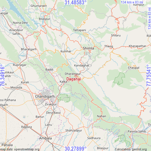
Dagshai GPS coordinates[2]
30° 53' 3.516" North, 77° 3' 8.208" East
| Map corner | latitude | longitude |
|---|---|---|
| Upper-left | 31.48583°, | 76.34916° |
| Center: | 30.88431°, | 77.05228° |
| Lower-right: | 30.27899°, | 77.75541° |
| Map W x H: | 134.2×134.2 km | = 83.4×83.4mi |
| max Lat: | 34.9274° ⇑4.6% North |
| Dagshai: | 30.88431° |
| min Lat: | ⇓95.4% South 8.09008° |
| min Long | Dagshai | max Long |
| 68.82655° | 77.05228° | 96.81° |
| W 37.5%⇐ | ⇒62.5% E |
Elevation
Elevation of Dagshai is 1824 m = 5984 ft, and this is 1528.4 m = 5014 ft above average elevation for this country.
| Max E: |
3681 m = 12077 ft | 0.90000000000001% |
| Dagshai | 1824 m 5984 ft | |
| Avg. | 295.6 m = 970 ft | |
Min E: |
1 m = 3 ft | 99.1% |
See also: India elevation on elevation.city.
Geographical zone
Dagshai is located in North temperate zone (between Tropic of Cancer and the Arctic Circle). Distance of this Northern Tropic circle is 828.1 km =514.6 mi to South.| Distance of | km | miles | from Dagshai |
|---|---|---|---|
| North Pole | 6573 | 4084.3 | to North |
| Arctic Circle | 3967.2 | 2465.1 | to North |
| Tropic Cancer | 828.1 | 514.6 | to South |
| Equator | 3434 | 2133.8 | to South |


Nearby cities:
15 places around Dagshai: (largest is in red/bold)
• Arki
30.9 km =19.2 mi,  344°
344°
• Baddi
26.2 km =16.3 mi,  288°
288°
• Basi
38.4 km =23.9 mi,  211°
211°
• Chandigarh
30.1 km =18.7 mi,  236°
236°
• Jutogh
24.8 km =15.4 mi,  14°
14°
• Kasauli
8.4 km =5.2 mi,  280°
280°
• Kālka
11.7 km =7.3 mi,  245°
245°
• Nālāgarh
36 km =22.4 mi,  299°
299°
• Panchkula
28.6 km =17.8 mi,  222°
222°
• Parwanoo
10.1 km =6.3 mi, 238°
• Pinjaur
15.9 km =9.9 mi,  233°
233°
• Rājgarh
24 km =14.9 mi,  98°
98°
• Sabāthu
11.6 km =7.2 mi,  330°
330°
• Shimla
26.8 km =16.7 mi,  24°
24°
• Solan
6 km =3.7 mi,  62°
62°
Sources, notices
• [Note1] Compared only with cities in India existing in our database
• [Src1] Map data: © OpenStreetMap contributors (CC-BY-SA)
• [Src2] Other city data from geonames.org with taken over terms of usage.
• [Src3] Geographical zone / Annual Mean Temperature by Robert A. Rohde @ Wikipedia
