Noida geodata
Noida (Uttar Pradesh) is a populated place; located in India in Asia/Kolkata (GMT+5.5) time zone. With population of 293,908 people, there are 149 cities with bigger population in this country. Compared to other cities in India, 87.1% of cities are located further ↓South; 59.2% of cities are located further →East and 50.7% of cities have lower elevation than Noida. Note1


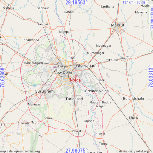
Noida GPS coordinates[2]
28° 34' 48" North, 77° 19' 48" East
| Map corner | latitude | longitude |
|---|---|---|
| Upper-left | 29.19563°, | 76.62688° |
| Center: | 28.58°, | 77.33° |
| Lower-right: | 27.96075°, | 78.03313° |
| Map W x H: | 137.3×137.3 km | = 85.3×85.3mi |
| max Lat: | 34.9274° ⇑12.9% North |
| Noida: | 28.58° |
| min Lat: | ⇓87.1% South 8.09008° |
| min Long | Noida | max Long |
| 68.82655° | 77.33° | 96.81° |
| W 40.8%⇐ | ⇒59.2% E |
Elevation
Elevation of Noida is 206 m = 676 ft, and this is 89.6 m = 294 ft below average elevation for this country.
| Max E: |
3681 m = 12077 ft | 49.3% |
| Avg. | 295.6 m = 970 ft | |
| Noida | 206 m = 676 ft | |
Min E: |
1 m = 3 ft | 50.7% |
See also: Noida elevation on elevation.city.
Geographical zone
Noida is located in North temperate zone (between Tropic of Cancer and the Arctic Circle). Distance of this Northern Tropic circle is 571.9 km =355.4 mi to South.| Distance of | km | miles | from Noida |
|---|---|---|---|
| North Pole | 6829.3 | 4243.5 | to North |
| Arctic Circle | 4223.4 | 2624.3 | to North |
| Tropic Cancer | 571.9 | 355.4 | to South |
| Equator | 3177.8 | 1974.6 | to South |


Nearby cities:
15 places around Noida: (largest is in red/bold)
• Defence Colony
9.5 km =5.9 mi,  264°
264°
• Delhi
12.5 km =7.8 mi,  309°
309°
• Deoli
12.9 km =8 mi,  228°
228°
• Dādri
22.1 km =13.7 mi,  97°
97°
• Dāsna
21.7 km =13.5 mi,  60°
60°
• Faridabad
18.8 km =11.7 mi,  185°
185°
• Ghāziābād
14.3 km =8.9 mi,  48°
48°
• Greater Noida
22.2 km =13.8 mi,  114°
114°
• Karol Bāgh
15.7 km =9.8 mi,  300°
300°
• Loni
19.5 km =12.1 mi,  348°
348°
• Murādnagar
27.7 km =17.2 mi,  36°
36°
• New Delhi
12 km =7.5 mi, 301°
• Pitampura
22.9 km =14.2 mi, 302°
• Sector
1.1 km =0.7 mi,  200°
200°
• Shahdara
18.7 km =11.6 mi,  277°
277°
Sources, notices
• [Note1] Compared only with cities in India existing in our database
• [Src1] Map data: © OpenStreetMap contributors (CC-BY-SA)
• [Src2] Other city data from geonames.org with taken over terms of usage.
• [Src3] Geographical zone / Annual Mean Temperature by Robert A. Rohde @ Wikipedia
