Ghiror geodata
Ghiror (Uttar Pradesh) is a populated place; located in India in Asia/Kolkata (GMT+5.5) time zone. With population of 14,011 people, there are 2565 cities with bigger population in this country. Compared to other cities in India, 80.1% of cities are located further ↓South; 56.9% of cities are located further ←West and 57.2% of cities have higher elevation than Ghiror. Note1


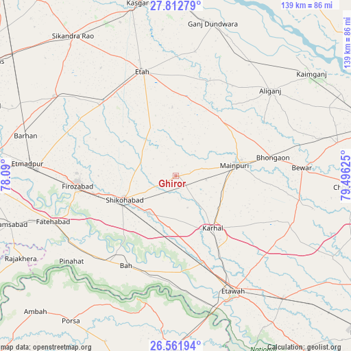
Ghiror GPS coordinates[2]
27° 11' 20.832" North, 78° 47' 35.232" East
| Map corner | latitude | longitude |
|---|---|---|
| Upper-left | 27.81279°, | 78.09° |
| Center: | 27.18912°, | 78.79312° |
| Lower-right: | 26.56194°, | 79.49625° |
| Map W x H: | 139.1×139.1 km | = 86.4×86.4mi |
| max Lat: | 34.9274° ⇑19.9% North |
| Ghiror: | 27.18912° |
| min Lat: | ⇓80.1% South 8.09008° |
| min Long | Ghiror | max Long |
| 68.82655° | 78.79312° | 96.81° |
| W 56.9%⇐ | ⇒43.1% E |
Elevation
Elevation of Ghiror is 162 m = 531 ft, and this is 133.6 m = 438 ft below average elevation for this country.
| Max E: |
3681 m = 12077 ft | 57.2% |
| Avg. | 295.6 m = 970 ft | |
| Ghiror | 162 m = 531 ft | |
Min E: |
1 m = 3 ft | 42.8% |
See also: India elevation on elevation.city.
Geographical zone
Ghiror is located in North temperate zone (between Tropic of Cancer and the Arctic Circle). Distance of this Northern Tropic circle is 417.2 km =259.2 mi to South.| Distance of | km | miles | from Ghiror |
|---|---|---|---|
| North Pole | 6983.9 | 4339.6 | to North |
| Arctic Circle | 4378 | 2720.4 | to North |
| Tropic Cancer | 417.2 | 259.2 | to South |
| Equator | 3023.1 | 1878.5 | to South |


Nearby cities:
15 places around Ghiror: (largest is in red/bold)
• Bewar
50 km =31.1 mi,  86°
86°
• Bhongaon
39.1 km =24.3 mi,  79°
79°
• Bāh
40.7 km =25.3 mi,  209°
209°
• Fīrozābād
39.3 km =24.4 mi,  263°
263°
• Jasrāna
14.9 km =9.3 mi,  290°
290°
• Jaswantnagar
35.8 km =22.2 mi,  162°
162°
• Karhal
25.4 km =15.8 mi,  145°
145°
• Kishni
49.9 km =31 mi,  111°
111°
• Mainpuri
23.7 km =14.7 mi, 79°
• Nagla Panchi
33.5 km =20.8 mi,  104°
104°
• Pharihā
34.9 km =21.7 mi, 294°
• Sakīt
27.3 km =17 mi,  357°
357°
• Shikohābād
22.3 km =13.9 mi,  246°
246°
• Sidhpura
49.9 km =31 mi,  8°
8°
• Sirsāganj
18.1 km =11.2 mi,  215°
215°
Sources, notices
• [Note1] Compared only with cities in India existing in our database
• [Src1] Map data: © OpenStreetMap contributors (CC-BY-SA)
• [Src2] Other city data from geonames.org with taken over terms of usage.
• [Src3] Geographical zone / Annual Mean Temperature by Robert A. Rohde @ Wikipedia
