Hawai geodata
Hawai (Arunachal Pradesh) is a seat of a second-order administrative division; located in India in Asia/Kolkata (GMT+5.5) time zone. In our database, there are 3475 cities with bigger population. Compared to other cities in India, 83.9% of cities are located further ↓South; 100% of cities are located further ←West and 97.1% of cities have lower elevation than Hawai. Note1


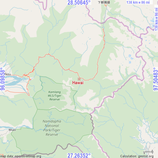
Hawai GPS coordinates[2]
27° 53' 12.372" North, 96° 48' 6.12" East
| Map corner | latitude | longitude |
|---|---|---|
| Upper-left | 28.50645°, | 96.09858° |
| Center: | 27.88677°, | 96.8017° |
| Lower-right: | 27.26352°, | 97.50483° |
| Map W x H: | 138.2×138.2 km | = 85.9×85.9mi |
| max Lat: | 34.9274° ⇑16.1% North |
| Hawai: | 27.88677° |
| min Lat: | ⇓83.9% South 8.09008° |
| min Long | Hawai | max Long |
| 68.82655° | 96.8017° | 96.81° |
| W 100%⇐ | ⇒0% E |
Elevation
Elevation of Hawai is 1289 m = 4229 ft, and this is 993.4 m = 3259 ft above average elevation for this country.
| Max E: |
3681 m = 12077 ft | 2.9% |
| Hawai | 1289 m 4229 ft | |
| Avg. | 295.6 m = 970 ft | |
Min E: |
1 m = 3 ft | 97.1% |
See also: India elevation on elevation.city.
Geographical zone
Hawai is located in North temperate zone (between Tropic of Cancer and the Arctic Circle). Distance of this Northern Tropic circle is 494.8 km =307.5 mi to South.| Distance of | km | miles | from Hawai |
|---|---|---|---|
| North Pole | 6906.3 | 4291.4 | to North |
| Arctic Circle | 4300.5 | 2672.2 | to North |
| Tropic Cancer | 494.8 | 307.5 | to South |
| Equator | 3100.7 | 1926.7 | to South |


Nearby cities:
15 places around Hawai: (largest is in red/bold)
• Chābua
166.4 km =103.4 mi,  254°
254°
• Digboi
128.8 km =80 mi,  244°
244°
• Duliāgaon
157.9 km =98.1 mi, 248°
• Dum Duma
127.5 km =79.2 mi, 253°
• Hayuliang
32.8 km =20.4 mi,  309°
309°
• Khonsa
155.6 km =96.7 mi,  231°
231°
• Margherita
130.2 km =80.9 mi, 239°
• Mākum
141.6 km =88 mi, 251°
• Nahorkatiya
158.5 km =98.5 mi, 245°
• Namsai
95.4 km =59.3 mi,  255°
255°
• Nāmrup
165.2 km =102.7 mi, 242°
• Pangin
181.5 km =112.8 mi,  281°
281°
• Pāsighāt
146.2 km =90.8 mi, 277°
• Tezu
66.2 km =41.1 mi,  272°
272°
• Tinsukia
148.7 km =92.4 mi, 252°
Sources, notices
• [Note1] Compared only with cities in India existing in our database
• [Src1] Map data: © OpenStreetMap contributors (CC-BY-SA)
• [Src2] Other city data from geonames.org with taken over terms of usage.
• [Src3] Geographical zone / Annual Mean Temperature by Robert A. Rohde @ Wikipedia
