Nāmrup geodata
Nāmrup (Assam) is a populated place; located in India in Asia/Kolkata (GMT+5.5) time zone. With population of 18,432 people, there are 2168 cities with bigger population in this country. Compared to other cities in India, 80.1% of cities are located further ↓South; 99.6% of cities are located further ←West and 64.6% of cities have higher elevation than Nāmrup. Note1


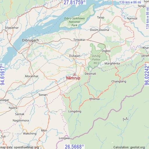
Nāmrup GPS coordinates[2]
27° 11' 38.22" North, 95° 19' 9.444" East
| Map corner | latitude | longitude |
|---|---|---|
| Upper-left | 27.81759°, | 94.61617° |
| Center: | 27.19395°, | 95.31929° |
| Lower-right: | 26.5668°, | 96.02242° |
| Map W x H: | 139.1×139.1 km | = 86.4×86.4mi |
| max Lat: | 34.9274° ⇑19.9% North |
| Nāmrup: | 27.19395° |
| min Lat: | ⇓80.1% South 8.09008° |
| min Long | Nāmrup | max Long |
| 68.82655° | 95.31929° | 96.81° |
| W 99.6%⇐ | ⇒0.40000000000001% E |
Elevation
Elevation of Nāmrup is 123 m = 404 ft, and this is 172.6 m = 566 ft below average elevation for this country.
| Max E: |
3681 m = 12077 ft | 64.6% |
| Avg. | 295.6 m = 970 ft | |
| Nāmrup | 123 m = 404 ft | |
Min E: |
1 m = 3 ft | 35.4% |
See also: India elevation on elevation.city.
Geographical zone
Nāmrup is located in North temperate zone (between Tropic of Cancer and the Arctic Circle). Distance of this Northern Tropic circle is 417.8 km =259.6 mi to South.| Distance of | km | miles | from Nāmrup |
|---|---|---|---|
| North Pole | 6983.4 | 4339.3 | to North |
| Arctic Circle | 4377.5 | 2720.1 | to North |
| Tropic Cancer | 417.8 | 259.6 | to South |
| Equator | 3023.7 | 1878.8 | to South |


Nearby cities:
15 places around Nāmrup: (largest is in red/bold)
• Chābua
35.1 km =21.8 mi,  335°
335°
• Dibrugarh
51.6 km =32.1 mi,  308°
308°
• Digboi
36.9 km =22.9 mi,  53°
53°
• Duliāgaon
19.9 km =12.4 mi,  356°
356°
• Dum Duma
47.8 km =29.7 mi,  29°
29°
• Khonsa
31.4 km =19.5 mi,  128°
128°
• Margherita
35.9 km =22.3 mi,  73°
73°
• Mon
57.1 km =35.5 mi,  206°
206°
• Morānha
39.9 km =24.8 mi,  268°
268°
• Mākum
34.5 km =21.4 mi,  19°
19°
• Nahorkatiya
10.8 km =6.7 mi,  11°
11°
• Nāzirā
65.5 km =40.7 mi,  241°
241°
• Sonari
31.8 km =19.8 mi,  245°
245°
• Sonāri
35.4 km =22 mi, 237°
• Tinsukia
33.1 km =20.6 mi, 6°
Sources, notices
• [Note1] Compared only with cities in India existing in our database
• [Src1] Map data: © OpenStreetMap contributors (CC-BY-SA)
• [Src2] Other city data from geonames.org with taken over terms of usage.
• [Src3] Geographical zone / Annual Mean Temperature by Robert A. Rohde @ Wikipedia
