Pāsighāt geodata
Pāsighāt (Arunachal Pradesh) is a populated place; located in India in Asia/Kolkata (GMT+5.5) time zone. With population of 25,581 people, there are 1662 cities with bigger population in this country. Compared to other cities in India, 84.8% of cities are located further ↓South; 99.7% of cities are located further ←West and 54.3% of cities have higher elevation than Pāsighāt. Note1


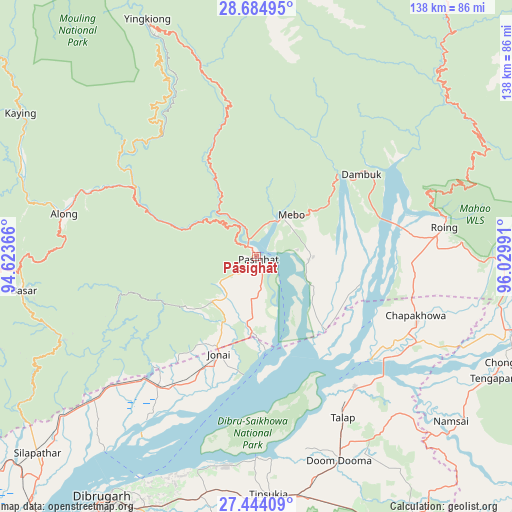
Pāsighāt GPS coordinates[2]
28° 3' 58.716" North, 95° 19' 36.408" East
| Map corner | latitude | longitude |
|---|---|---|
| Upper-left | 28.68495°, | 94.62366° |
| Center: | 28.06631°, | 95.32678° |
| Lower-right: | 27.44409°, | 96.02991° |
| Map W x H: | 138×138 km | = 85.7×85.7mi |
| max Lat: | 34.9274° ⇑15.2% North |
| Pāsighāt: | 28.06631° |
| min Lat: | ⇓84.8% South 8.09008° |
| min Long | Pāsighāt | max Long |
| 68.82655° | 95.32678° | 96.81° |
| W 99.7%⇐ | ⇒0.3% E |
Elevation
Elevation of Pāsighāt is 179 m = 587 ft, and this is 116.6 m = 383 ft below average elevation for this country.
| Max E: |
3681 m = 12077 ft | 54.3% |
| Avg. | 295.6 m = 970 ft | |
| Pāsighāt | 179 m = 587 ft | |
Min E: |
1 m = 3 ft | 45.7% |
See also: India elevation on elevation.city.
Geographical zone
Pāsighāt is located in North temperate zone (between Tropic of Cancer and the Arctic Circle). Distance of this Northern Tropic circle is 514.8 km =319.9 mi to South.| Distance of | km | miles | from Pāsighāt |
|---|---|---|---|
| North Pole | 6886.4 | 4279 | to North |
| Arctic Circle | 4280.5 | 2659.8 | to North |
| Tropic Cancer | 514.8 | 319.9 | to South |
| Equator | 3120.7 | 1939.1 | to South |


Nearby cities:
15 places around Pāsighāt: (largest is in red/bold)
• Along
52.9 km =32.9 mi,  282°
282°
• Bāsār
62.6 km =38.9 mi,  262°
262°
• Chābua
66.6 km =41.4 mi,  192°
192°
• Dibrugarh
77.1 km =47.9 mi,  212°
212°
• Digboi
80.2 km =49.8 mi,  159°
159°
• Duliāgaon
77.2 km =48 mi,  181°
181°
• Dum Duma
59.8 km =37.2 mi, 157°
• Margherita
93.2 km =57.9 mi, 158°
• Mākum
65.4 km =40.6 mi,  170°
170°
• Nahorkatiya
86.4 km =53.7 mi, 179°
• Namsai
68.8 km =42.8 mi,  129°
129°
• Pangin
36.8 km =22.9 mi,  295°
295°
• Silapathar
79.2 km =49.2 mi,  228°
228°
• Tezu
80.6 km =50.1 mi,  102°
102°
• Tinsukia
64.3 km =40 mi, 177°
Sources, notices
• [Note1] Compared only with cities in India existing in our database
• [Src1] Map data: © OpenStreetMap contributors (CC-BY-SA)
• [Src2] Other city data from geonames.org with taken over terms of usage.
• [Src3] Geographical zone / Annual Mean Temperature by Robert A. Rohde @ Wikipedia
