Tezu geodata
Tezu (Arunachal Pradesh) is a populated place; located in India in Asia/Kolkata (GMT+5.5) time zone. With population of 14,927 people, there are 2471 cities with bigger population in this country. Compared to other cities in India, 84.1% of cities are located further ↓South; 99.9% of cities are located further ←West and 50.1% of cities have lower elevation than Tezu. Note1


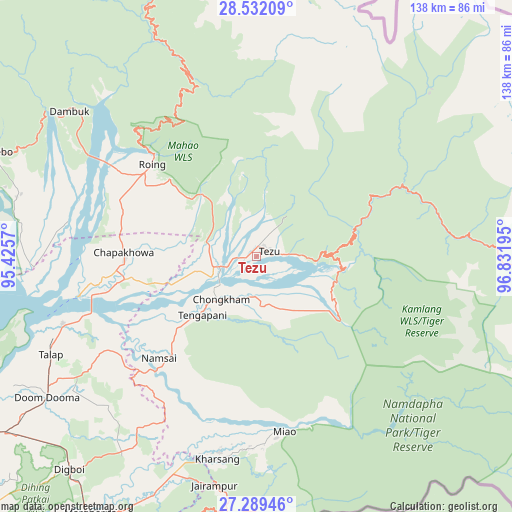
Tezu GPS coordinates[2]
27° 54' 45.216" North, 96° 7' 43.752" East
| Map corner | latitude | longitude |
|---|---|---|
| Upper-left | 28.53209°, | 95.4257° |
| Center: | 27.91256°, | 96.12882° |
| Lower-right: | 27.28946°, | 96.83195° |
| Map W x H: | 138.2×138.2 km | = 85.9×85.9mi |
| max Lat: | 34.9274° ⇑15.9% North |
| Tezu: | 27.91256° |
| min Lat: | ⇓84.1% South 8.09008° |
| min Long | Tezu | max Long |
| 68.82655° | 96.12882° | 96.81° |
| W 99.9%⇐ | ⇒0.099999999999994% E |
Elevation
Elevation of Tezu is 202 m = 663 ft, and this is 93.6 m = 307 ft below average elevation for this country.
| Max E: |
3681 m = 12077 ft | 49.9% |
| Avg. | 295.6 m = 970 ft | |
| Tezu | 202 m = 663 ft | |
Min E: |
1 m = 3 ft | 50.1% |
See also: India elevation on elevation.city.
Geographical zone
Tezu is located in North temperate zone (between Tropic of Cancer and the Arctic Circle). Distance of this Northern Tropic circle is 497.7 km =309.3 mi to South.| Distance of | km | miles | from Tezu |
|---|---|---|---|
| North Pole | 6903.5 | 4289.6 | to North |
| Arctic Circle | 4297.6 | 2670.4 | to North |
| Tropic Cancer | 497.7 | 309.3 | to South |
| Equator | 3103.6 | 1928.5 | to South |


Nearby cities:
15 places around Tezu: (largest is in red/bold)
• Chābua
105.4 km =65.5 mi,  243°
243°
• Digboi
76.6 km =47.6 mi,  221°
221°
• Duliāgaon
100.8 km =62.6 mi,  233°
233°
• Dum Duma
68.1 km =42.3 mi, 235°
• Hawai
66.2 km =41.1 mi,  92°
92°
• Hayuliang
44.4 km =27.6 mi,  66°
66°
• Khonsa
114 km =70.8 mi,  209°
209°
• Margherita
83.3 km =51.8 mi, 213°
• Mākum
83 km =51.6 mi, 235°
• Nahorkatiya
104 km =64.6 mi, 228°
• Namsai
37.6 km =23.4 mi, 223°
• Nāmrup
112.9 km =70.2 mi, 224°
• Pangin
116.7 km =72.5 mi,  286°
286°
• Pāsighāt
80.6 km =50.1 mi,  282°
282°
• Tinsukia
89.1 km =55.4 mi, 238°
Sources, notices
• [Note1] Compared only with cities in India existing in our database
• [Src1] Map data: © OpenStreetMap contributors (CC-BY-SA)
• [Src2] Other city data from geonames.org with taken over terms of usage.
• [Src3] Geographical zone / Annual Mean Temperature by Robert A. Rohde @ Wikipedia
