Margherita geodata
Margherita (Arunachal Pradesh) is a populated place; located in India in Asia/Kolkata (GMT+5.5) time zone. With population of 24,428 people, there are 1743 cities with bigger population in this country. Compared to other cities in India, 80.6% of cities are located further ↓South; 99.9% of cities are located further ←West and 59.1% of cities have higher elevation than Margherita. Note1


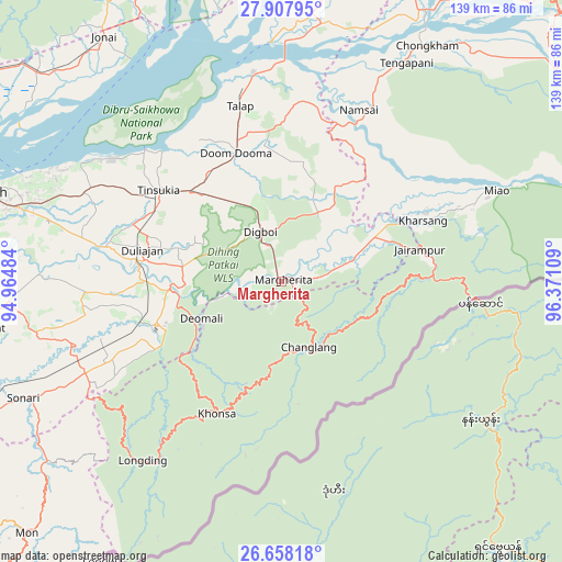
Margherita GPS coordinates[2]
27° 17' 5.352" North, 95° 40' 4.656" East
| Map corner | latitude | longitude |
|---|---|---|
| Upper-left | 27.90795°, | 94.96484° |
| Center: | 27.28482°, | 95.66796° |
| Lower-right: | 26.65818°, | 96.37109° |
| Map W x H: | 139×139 km | = 86.4×86.4mi |
| max Lat: | 34.9274° ⇑19.4% North |
| Margherita: | 27.28482° |
| min Lat: | ⇓80.6% South 8.09008° |
| min Long | Margherita | max Long |
| 68.82655° | 95.66796° | 96.81° |
| W 99.9%⇐ | ⇒0.099999999999994% E |
Elevation
Elevation of Margherita is 153 m = 502 ft, and this is 142.6 m = 468 ft below average elevation for this country.
| Max E: |
3681 m = 12077 ft | 59.1% |
| Avg. | 295.6 m = 970 ft | |
| Margherita | 153 m = 502 ft | |
Min E: |
1 m = 3 ft | 40.9% |
See also: India elevation on elevation.city.
Geographical zone
Margherita is located in North temperate zone (between Tropic of Cancer and the Arctic Circle). Distance of this Northern Tropic circle is 427.9 km =265.9 mi to South.| Distance of | km | miles | from Margherita |
|---|---|---|---|
| North Pole | 6973.3 | 4333 | to North |
| Arctic Circle | 4367.4 | 2713.8 | to North |
| Tropic Cancer | 427.9 | 265.9 | to South |
| Equator | 3033.8 | 1885.1 | to South |


Nearby cities:
15 places around Margherita: (largest is in red/bold)
• Chābua
53.4 km =33.2 mi,  294°
294°
• Dibrugarh
78.1 km =48.5 mi, 286°
• Digboi
13 km =8.1 mi,  337°
337°
• Duliāgaon
36.9 km =22.9 mi, 285°
• Dum Duma
33.4 km =20.8 mi, 340°
• Khonsa
31.5 km =19.6 mi,  198°
198°
• Morānha
75.2 km =46.7 mi,  261°
261°
• Mākum
32 km =19.9 mi,  314°
314°
• Nahorkatiya
32.2 km =20 mi,  270°
270°
• Namsai
46.9 km =29.1 mi,  24°
24°
• Nāmrup
35.9 km =22.3 mi,  253°
253°
• Sonari
67.6 km =42 mi, 249°
• Sonāri
70.7 km =43.9 mi, 245°
• Tezu
83.3 km =51.8 mi,  33°
33°
• Tinsukia
38 km =23.6 mi, 306°
Sources, notices
• [Note1] Compared only with cities in India existing in our database
• [Src1] Map data: © OpenStreetMap contributors (CC-BY-SA)
• [Src2] Other city data from geonames.org with taken over terms of usage.
• [Src3] Geographical zone / Annual Mean Temperature by Robert A. Rohde @ Wikipedia
