Dum Duma geodata
Dum Duma (Assam) is a populated place; located in India in Asia/Kolkata (GMT+5.5) time zone. With population of 21,706 people, there are 1921 cities with bigger population in this country. Compared to other cities in India, 82.3% of cities are located further ↓South; 99.8% of cities are located further ←West and 63.2% of cities have higher elevation than Dum Duma. Note1


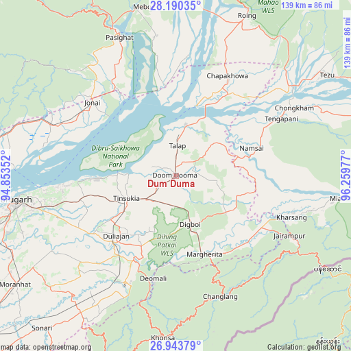
Dum Duma GPS coordinates[2]
27° 34' 7.824" North, 95° 33' 23.904" East
| Map corner | latitude | longitude |
|---|---|---|
| Upper-left | 28.19035°, | 94.85352° |
| Center: | 27.56884°, | 95.55664° |
| Lower-right: | 26.94379°, | 96.25977° |
| Map W x H: | 138.6×138.6 km | = 86.1×86.1mi |
| max Lat: | 34.9274° ⇑17.7% North |
| Dum Duma: | 27.56884° |
| min Lat: | ⇓82.3% South 8.09008° |
| min Long | Dum Duma | max Long |
| 68.82655° | 95.55664° | 96.81° |
| W 99.8%⇐ | ⇒0.2% E |
Elevation
Elevation of Dum Duma is 131 m = 430 ft, and this is 164.6 m = 540 ft below average elevation for this country.
| Max E: |
3681 m = 12077 ft | 63.2% |
| Avg. | 295.6 m = 970 ft | |
| Dum Duma | 131 m = 430 ft | |
Min E: |
1 m = 3 ft | 36.8% |
See also: India elevation on elevation.city.
Geographical zone
Dum Duma is located in North temperate zone (between Tropic of Cancer and the Arctic Circle). Distance of this Northern Tropic circle is 459.4 km =285.5 mi to South.| Distance of | km | miles | from Dum Duma |
|---|---|---|---|
| North Pole | 6941.7 | 4313.4 | to North |
| Arctic Circle | 4335.8 | 2694.1 | to North |
| Tropic Cancer | 459.4 | 285.5 | to South |
| Equator | 3065.4 | 1904.8 | to South |


Nearby cities:
15 places around Dum Duma: (largest is in red/bold)
• Chābua
38.9 km =24.2 mi,  255°
255°
• Dibrugarh
64.7 km =40.2 mi, 261°
• Digboi
20.5 km =12.7 mi,  162°
162°
• Duliāgaon
32.9 km =20.4 mi,  228°
228°
• Khonsa
61.4 km =38.2 mi,  179°
179°
• Margherita
33.4 km =20.8 mi, 160°
• Morānha
76.2 km =47.3 mi,  236°
236°
• Mākum
15 km =9.3 mi, 232°
• Nahorkatiya
37.6 km =23.4 mi,  214°
214°
• Namsai
32.3 km =20.1 mi,  69°
69°
• Nāmrup
47.8 km =29.7 mi, 209°
• Pāsighāt
59.8 km =37.2 mi,  337°
337°
• Sonari
75.9 km =47.2 mi,  223°
223°
• Tezu
68.1 km =42.3 mi,  55°
55°
• Tinsukia
21.3 km =13.2 mi,  245°
245°
Sources, notices
• [Note1] Compared only with cities in India existing in our database
• [Src1] Map data: © OpenStreetMap contributors (CC-BY-SA)
• [Src2] Other city data from geonames.org with taken over terms of usage.
• [Src3] Geographical zone / Annual Mean Temperature by Robert A. Rohde @ Wikipedia
