Tinsukia geodata
Tinsukia (Assam) is a populated place; located in India in Asia/Kolkata (GMT+5.5) time zone. With population of 89,373 people, there are 499 cities with bigger population in this country. Compared to other cities in India, 81.7% of cities are located further ↓South; 99.7% of cities are located further ←West and 63.8% of cities have higher elevation than Tinsukia. Note1


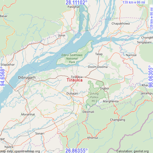
Tinsukia GPS coordinates[2]
27° 29' 20.58" North, 95° 21' 35.712" East
| Map corner | latitude | longitude |
|---|---|---|
| Upper-left | 28.11102°, | 94.6568° |
| Center: | 27.48905°, | 95.35992° |
| Lower-right: | 26.86355°, | 96.06305° |
| Map W x H: | 138.7×138.7 km | = 86.2×86.2mi |
| max Lat: | 34.9274° ⇑18.3% North |
| Tinsukia: | 27.48905° |
| min Lat: | ⇓81.7% South 8.09008° |
| min Long | Tinsukia | max Long |
| 68.82655° | 95.35992° | 96.81° |
| W 99.7%⇐ | ⇒0.3% E |
Elevation
Elevation of Tinsukia is 128 m = 420 ft, and this is 167.6 m = 550 ft below average elevation for this country.
| Max E: |
3681 m = 12077 ft | 63.8% |
| Avg. | 295.6 m = 970 ft | |
| Tinsukia | 128 m = 420 ft | |
Min E: |
1 m = 3 ft | 36.2% |
See also: Tinsukia elevation on elevation.city.
Geographical zone
Tinsukia is located in North temperate zone (between Tropic of Cancer and the Arctic Circle). Distance of this Northern Tropic circle is 450.6 km =280 mi to South.| Distance of | km | miles | from Tinsukia |
|---|---|---|---|
| North Pole | 6950.6 | 4318.9 | to North |
| Arctic Circle | 4344.7 | 2699.7 | to North |
| Tropic Cancer | 450.6 | 280 | to South |
| Equator | 3056.5 | 1899.2 | to South |


Nearby cities:
15 places around Tinsukia: (largest is in red/bold)
• Chābua
18.3 km =11.4 mi,  267°
267°
• Dibrugarh
44.6 km =27.7 mi, 268°
• Digboi
27.6 km =17.1 mi,  112°
112°
• Duliāgaon
14 km =8.7 mi,  201°
201°
• Dum Duma
21.3 km =13.2 mi,  65°
65°
• Khonsa
56.4 km =35 mi,  158°
158°
• Margherita
38 km =23.6 mi,  126°
126°
• Morānha
55.2 km =34.3 mi,  232°
232°
• Mākum
7.6 km =4.7 mi,  92°
92°
• Nahorkatiya
22.3 km =13.9 mi,  184°
184°
• Namsai
53.6 km =33.3 mi, 68°
• Nāmrup
33.1 km =20.6 mi,  186°
186°
• Silapathar
63.8 km =39.6 mi,  280°
280°
• Sonari
56.7 km =35.2 mi,  215°
215°
• Sonāri
61.8 km =38.4 mi,  213°
213°
Sources, notices
• [Note1] Compared only with cities in India existing in our database
• [Src1] Map data: © OpenStreetMap contributors (CC-BY-SA)
• [Src2] Other city data from geonames.org with taken over terms of usage.
• [Src3] Geographical zone / Annual Mean Temperature by Robert A. Rohde @ Wikipedia
