Pangin geodata
Pangin (Arunachal Pradesh) is a seat of a second-order administrative division; located in India in Asia/Kolkata (GMT+5.5) time zone. In our database, there are 3475 cities with bigger population. Compared to other cities in India, 85.4% of cities are located further ↓South; 99.5% of cities are located further ←West and 83.1% of cities have lower elevation than Pangin. Note1


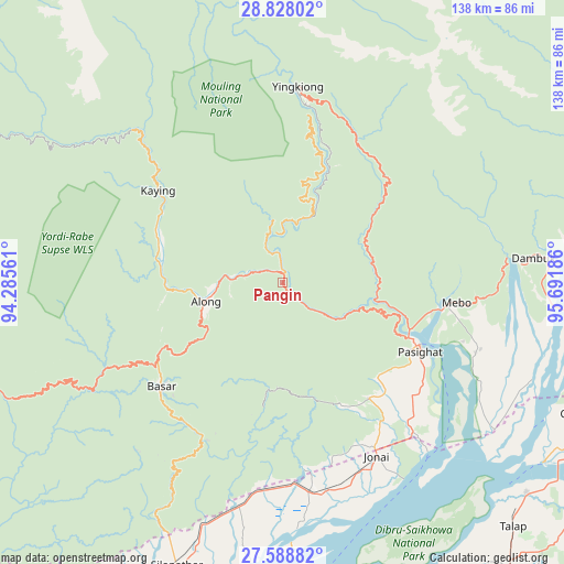
Pangin GPS coordinates[2]
28° 12' 36.792" North, 94° 59' 19.428" East
| Map corner | latitude | longitude |
|---|---|---|
| Upper-left | 28.82802°, | 94.28561° |
| Center: | 28.21022°, | 94.98873° |
| Lower-right: | 27.58882°, | 95.69186° |
| Map W x H: | 137.8×137.8 km | = 85.6×85.6mi |
| max Lat: | 34.9274° ⇑14.6% North |
| Pangin: | 28.21022° |
| min Lat: | ⇓85.4% South 8.09008° |
| min Long | Pangin | max Long |
| 68.82655° | 94.98873° | 96.81° |
| W 99.5%⇐ | ⇒0.5% E |
Elevation
Elevation of Pangin is 509 m = 1670 ft, and this is 213.4 m = 700 ft above average elevation for this country.
| Max E: |
3681 m = 12077 ft | 16.9% |
| Pangin | 509 m 1670 ft | |
| Avg. | 295.6 m = 970 ft | |
Min E: |
1 m = 3 ft | 83.1% |
See also: India elevation on elevation.city.
Geographical zone
Pangin is located in North temperate zone (between Tropic of Cancer and the Arctic Circle). Distance of this Northern Tropic circle is 530.8 km =329.8 mi to South.| Distance of | km | miles | from Pangin |
|---|---|---|---|
| North Pole | 6870.4 | 4269.1 | to North |
| Arctic Circle | 4264.5 | 2649.8 | to North |
| Tropic Cancer | 530.8 | 329.8 | to South |
| Equator | 3136.7 | 1949.1 | to South |


Nearby cities:
15 places around Pangin: (largest is in red/bold)
• Along
19 km =11.8 mi,  256°
256°
• Bāsār
37.8 km =23.5 mi,  229°
229°
• Chābua
82.9 km =51.5 mi,  167°
167°
• Dhemāji
90.1 km =56 mi,  206°
206°
• Dibrugarh
81.6 km =50.7 mi,  185°
185°
• Digboi
109.9 km =68.3 mi,  145°
145°
• Duliāgaon
98.3 km =61.1 mi,  161°
161°
• Dum Duma
90.6 km =56.3 mi,  141°
141°
• Morānha
114 km =70.8 mi,  183°
183°
• Mākum
91.7 km =57 mi, 151°
• Nahorkatiya
108.1 km =67.2 mi, 161°
• Namsai
104.9 km =65.2 mi,  124°
124°
• Pāsighāt
36.8 km =22.9 mi, 115°
• Silapathar
73.2 km =45.5 mi,  200°
200°
• Tinsukia
88.1 km =54.7 mi, 155°
Sources, notices
• [Note1] Compared only with cities in India existing in our database
• [Src1] Map data: © OpenStreetMap contributors (CC-BY-SA)
• [Src2] Other city data from geonames.org with taken over terms of usage.
• [Src3] Geographical zone / Annual Mean Temperature by Robert A. Rohde @ Wikipedia
