Khonsa geodata
Khonsa (Arunachal Pradesh) is a populated place; located in India in Asia/Kolkata (GMT+5.5) time zone. With population of 10,187 people, there are 2924 cities with bigger population in this country. Compared to other cities in India, 78.4% of cities are located further ↓South; 99.8% of cities are located further ←West and 95.7% of cities have lower elevation than Khonsa. Note1


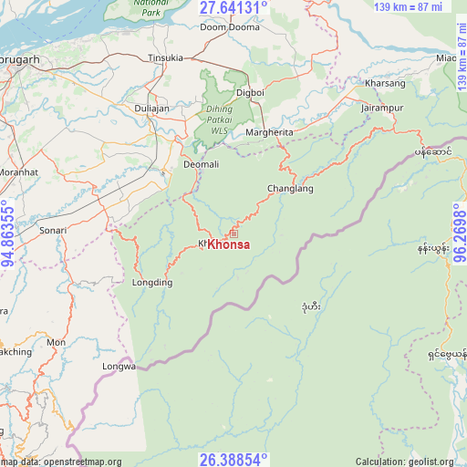
Khonsa GPS coordinates[2]
27° 1' 0.012" North, 95° 34' 0.012" East
| Map corner | latitude | longitude |
|---|---|---|
| Upper-left | 27.64131°, | 94.86355° |
| Center: | 27.01667°, | 95.56667° |
| Lower-right: | 26.38854°, | 96.2698° |
| Map W x H: | 139.3×139.3 km | = 86.6×86.6mi |
| max Lat: | 34.9274° ⇑21.6% North |
| Khonsa: | 27.01667° |
| min Lat: | ⇓78.4% South 8.09008° |
| min Long | Khonsa | max Long |
| 68.82655° | 95.56667° | 96.81° |
| W 99.8%⇐ | ⇒0.2% E |
Elevation
Elevation of Khonsa is 946 m = 3104 ft, and this is 650.4 m = 2134 ft above average elevation for this country.
| Max E: |
3681 m = 12077 ft | 4.3% |
| Khonsa | 946 m 3104 ft | |
| Avg. | 295.6 m = 970 ft | |
Min E: |
1 m = 3 ft | 95.7% |
See also: India elevation on elevation.city.
Geographical zone
Khonsa is located in North temperate zone (between Tropic of Cancer and the Arctic Circle). Distance of this Northern Tropic circle is 398.1 km =247.4 mi to South.| Distance of | km | miles | from Khonsa |
|---|---|---|---|
| North Pole | 7003.1 | 4351.5 | to North |
| Arctic Circle | 4397.2 | 2732.3 | to North |
| Tropic Cancer | 398.1 | 247.4 | to South |
| Equator | 3004 | 1866.6 | to South |


Nearby cities:
15 places around Khonsa: (largest is in red/bold)
• Chābua
64.7 km =40.2 mi,  323°
323°
• Dibrugarh
83 km =51.6 mi,  308°
308°
• Digboi
42.2 km =26.2 mi,  6°
6°
• Duliāgaon
47.1 km =29.3 mi,  327°
327°
• Dum Duma
61.4 km =38.2 mi,  359°
359°
• Margherita
31.5 km =19.6 mi,  18°
18°
• Mon
59.3 km =36.8 mi,  238°
238°
• Morānha
67.2 km =41.8 mi,  286°
286°
• Mākum
53.8 km =33.4 mi,  346°
346°
• Nahorkatiya
37.6 km =23.4 mi, 323°
• Namsai
78.3 km =48.7 mi, 22°
• Nāmrup
31.4 km =19.5 mi, 308°
• Sonari
53.8 km =33.4 mi,  276°
276°
• Sonāri
54.5 km =33.9 mi,  270°
270°
• Tinsukia
56.4 km =35 mi,  338°
338°
Sources, notices
• [Note1] Compared only with cities in India existing in our database
• [Src1] Map data: © OpenStreetMap contributors (CC-BY-SA)
• [Src2] Other city data from geonames.org with taken over terms of usage.
• [Src3] Geographical zone / Annual Mean Temperature by Robert A. Rohde @ Wikipedia
