Bāsār geodata
Bāsār (Arunachal Pradesh) is a populated place; located in India in Asia/Kolkata (GMT+5.5) time zone. With population of 4,157 people, there are 3372 cities with bigger population in this country. Compared to other cities in India, 84.4% of cities are located further ↓South; 99.2% of cities are located further ←West and 89.3% of cities have lower elevation than Bāsār. Note1


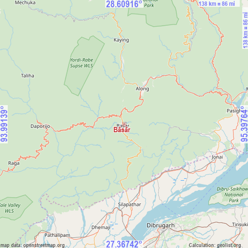
Bāsār GPS coordinates[2]
27° 59' 24.288" North, 94° 41' 40.236" East
| Map corner | latitude | longitude |
|---|---|---|
| Upper-left | 28.60916°, | 93.99139° |
| Center: | 27.99008°, | 94.69451° |
| Lower-right: | 27.36742°, | 95.39764° |
| Map W x H: | 138.1×138.1 km | = 85.8×85.8mi |
| max Lat: | 34.9274° ⇑15.6% North |
| Bāsār: | 27.99008° |
| min Lat: | ⇓84.4% South 8.09008° |
| min Long | Bāsār | max Long |
| 68.82655° | 94.69451° | 96.81° |
| W 99.2%⇐ | ⇒0.8% E |
Elevation
Elevation of Bāsār is 620 m = 2034 ft, and this is 324.4 m = 1064 ft above average elevation for this country.
| Max E: |
3681 m = 12077 ft | 10.7% |
| Bāsār | 620 m 2034 ft | |
| Avg. | 295.6 m = 970 ft | |
Min E: |
1 m = 3 ft | 89.3% |
See also: India elevation on elevation.city.
Geographical zone
Bāsār is located in North temperate zone (between Tropic of Cancer and the Arctic Circle). Distance of this Northern Tropic circle is 506.3 km =314.6 mi to South.| Distance of | km | miles | from Bāsār |
|---|---|---|---|
| North Pole | 6894.9 | 4284.3 | to North |
| Arctic Circle | 4289 | 2665.1 | to North |
| Tropic Cancer | 506.3 | 314.6 | to South |
| Equator | 3112.2 | 1933.8 | to South |


Nearby cities:
15 places around Bāsār: (largest is in red/bold)
• Along
22.5 km =14 mi,  27°
27°
• Chābua
73.6 km =45.7 mi,  140°
140°
• Dhemāji
57.4 km =35.7 mi,  190°
190°
• Dibrugarh
60.5 km =37.6 mi,  159°
159°
• Duliāgaon
91.4 km =56.8 mi, 138°
• Dum Duma
96.9 km =60.2 mi,  118°
118°
• Morānha
91.9 km =57.1 mi,  166°
166°
• Mākum
92 km =57.2 mi,  127°
127°
• Nahorkatiya
100.7 km =62.6 mi, 140°
• North Lakhimpur
102.2 km =63.5 mi,  214°
214°
• Pangin
37.8 km =23.5 mi,  49°
49°
• Pāsighāt
62.6 km =38.9 mi,  82°
82°
• Silapathar
44.1 km =27.4 mi,  176°
176°
• Tinsukia
86 km =53.4 mi, 130°
• Ziro
95 km =59 mi,  242°
242°
Sources, notices
• [Note1] Compared only with cities in India existing in our database
• [Src1] Map data: © OpenStreetMap contributors (CC-BY-SA)
• [Src2] Other city data from geonames.org with taken over terms of usage.
• [Src3] Geographical zone / Annual Mean Temperature by Robert A. Rohde @ Wikipedia
