Morānha geodata
Morānha (Assam) is a populated place; located in India in Asia/Kolkata (GMT+5.5) time zone. With population of 7,136 people, there are 3203 cities with bigger population in this country. Compared to other cities in India, 80% of cities are located further ↓South; 99.4% of cities are located further ←West and 67.6% of cities have higher elevation than Morānha. Note1


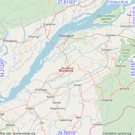
Morānha GPS coordinates[2]
27° 11' 14.46" North, 94° 54' 56.052" East
| Map corner | latitude | longitude |
|---|---|---|
| Upper-left | 27.81103°, | 94.21245° |
| Center: | 27.18735°, | 94.91557° |
| Lower-right: | 26.56016°, | 95.6187° |
| Map W x H: | 139.1×139.1 km | = 86.4×86.4mi |
| max Lat: | 34.9274° ⇑20% North |
| Morānha: | 27.18735° |
| min Lat: | ⇓80% South 8.09008° |
| min Long | Morānha | max Long |
| 68.82655° | 94.91557° | 96.81° |
| W 99.4%⇐ | ⇒0.59999999999999% E |
Elevation
Elevation of Morānha is 104 m = 341 ft, and this is 191.6 m = 629 ft below average elevation for this country.
| Max E: |
3681 m = 12077 ft | 67.6% |
| Avg. | 295.6 m = 970 ft | |
| Morānha | 104 m = 341 ft | |
Min E: |
1 m = 3 ft | 32.4% |
See also: India elevation on elevation.city.
Geographical zone
Morānha is located in North temperate zone (between Tropic of Cancer and the Arctic Circle). Distance of this Northern Tropic circle is 417 km =259.1 mi to South.| Distance of | km | miles | from Morānha |
|---|---|---|---|
| North Pole | 6984.1 | 4339.7 | to North |
| Arctic Circle | 4378.2 | 2720.5 | to North |
| Tropic Cancer | 417 | 259.1 | to South |
| Equator | 3022.9 | 1878.3 | to South |


Nearby cities:
15 places around Morānha: (largest is in red/bold)
• Amguri
56.6 km =35.2 mi,  222°
222°
• Chābua
41.6 km =25.8 mi,  37°
37°
• Dhemāji
46.5 km =28.9 mi,  315°
315°
• Dibrugarh
32.5 km =20.2 mi,  358°
358°
• Duliāgaon
43.9 km =27.3 mi,  62°
62°
• Mon
52.2 km =32.4 mi,  164°
164°
• Mākum
61.3 km =38.1 mi, 57°
• Nahorkatiya
43.6 km =27.1 mi,  74°
74°
• Nāmrup
39.9 km =24.8 mi,  88°
88°
• Nāzirā
35 km =21.7 mi,  210°
210°
• Sibsāgar
35.6 km =22.1 mi,  230°
230°
• Silapathar
49.1 km =30.5 mi,  337°
337°
• Sonari
16.8 km =10.4 mi,  138°
138°
• Sonāri
20.7 km =12.9 mi,  151°
151°
• Tinsukia
55.2 km =34.3 mi,  52°
52°
Sources, notices
• [Note1] Compared only with cities in India existing in our database
• [Src1] Map data: © OpenStreetMap contributors (CC-BY-SA)
• [Src2] Other city data from geonames.org with taken over terms of usage.
• [Src3] Geographical zone / Annual Mean Temperature by Robert A. Rohde @ Wikipedia
