Dibrugarh geodata
Dibrugarh (Assam) is a seat of a second-order administrative division; located in India in Asia/Kolkata (GMT+5.5) time zone. With population of 122,155 people, there are 359 cities with bigger population in this country. Compared to other cities in India, 81.6% of cities are located further ↓South; 99.4% of cities are located further ←West and 66.4% of cities have higher elevation than Dibrugarh. Note1


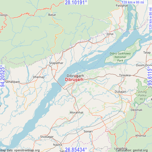
Dibrugarh GPS coordinates[2]
27° 28' 47.604" North, 94° 54' 30.132" East
| Map corner | latitude | longitude |
|---|---|---|
| Upper-left | 28.10191°, | 94.20525° |
| Center: | 27.47989°, | 94.90837° |
| Lower-right: | 26.85434°, | 95.6115° |
| Map W x H: | 138.7×138.7 km | = 86.2×86.2mi |
| max Lat: | 34.9274° ⇑18.4% North |
| Dibrugarh: | 27.47989° |
| min Lat: | ⇓81.6% South 8.09008° |
| min Long | Dibrugarh | max Long |
| 68.82655° | 94.90837° | 96.81° |
| W 99.4%⇐ | ⇒0.59999999999999% E |
Elevation
Elevation of Dibrugarh is 110 m = 361 ft, and this is 185.6 m = 609 ft below average elevation for this country.
| Max E: |
3681 m = 12077 ft | 66.4% |
| Avg. | 295.6 m = 970 ft | |
| Dibrugarh | 110 m = 361 ft | |
Min E: |
1 m = 3 ft | 33.6% |
See also: Dibrugarh elevation on elevation.city.
Geographical zone
Dibrugarh is located in North temperate zone (between Tropic of Cancer and the Arctic Circle). Distance of this Northern Tropic circle is 449.6 km =279.4 mi to South.| Distance of | km | miles | from Dibrugarh |
|---|---|---|---|
| North Pole | 6951.6 | 4319.5 | to North |
| Arctic Circle | 4345.7 | 2700.3 | to North |
| Tropic Cancer | 449.6 | 279.4 | to South |
| Equator | 3055.5 | 1898.6 | to South |


Nearby cities:
15 places around Dibrugarh: (largest is in red/bold)
• Bāsār
60.5 km =37.6 mi,  339°
339°
• Chābua
26.3 km =16.3 mi,  89°
89°
• Dhemāji
32.1 km =19.9 mi,  270°
270°
• Duliāgaon
41.2 km =25.6 mi,  106°
106°
• Dum Duma
64.7 km =40.2 mi,  81°
81°
• Morānha
32.5 km =20.2 mi,  178°
178°
• Mākum
52.1 km =32.4 mi, 89°
• Nahorkatiya
47.8 km =29.7 mi,  116°
116°
• Nāmrup
51.6 km =32.1 mi,  128°
128°
• Nāzirā
64.9 km =40.3 mi,  195°
195°
• Sibsāgar
61.3 km =38.1 mi,  205°
205°
• Silapathar
22.2 km =13.8 mi,  305°
305°
• Sonari
46.7 km =29 mi,  165°
165°
• Sonāri
51.7 km =32.1 mi, 168°
• Tinsukia
44.6 km =27.7 mi, 88°
Sources, notices
• [Note1] Compared only with cities in India existing in our database
• [Src1] Map data: © OpenStreetMap contributors (CC-BY-SA)
• [Src2] Other city data from geonames.org with taken over terms of usage.
• [Src3] Geographical zone / Annual Mean Temperature by Robert A. Rohde @ Wikipedia
