Along geodata
Along (Arunachal Pradesh) is a seat of a second-order administrative division; located in India in Asia/Kolkata (GMT+5.5) time zone. With population of 18,425 people, there are 2169 cities with bigger population in this country. Compared to other cities in India, 85.2% of cities are located further ↓South; 99.3% of cities are located further ←West and 62.5% of cities have lower elevation than Along. Note1


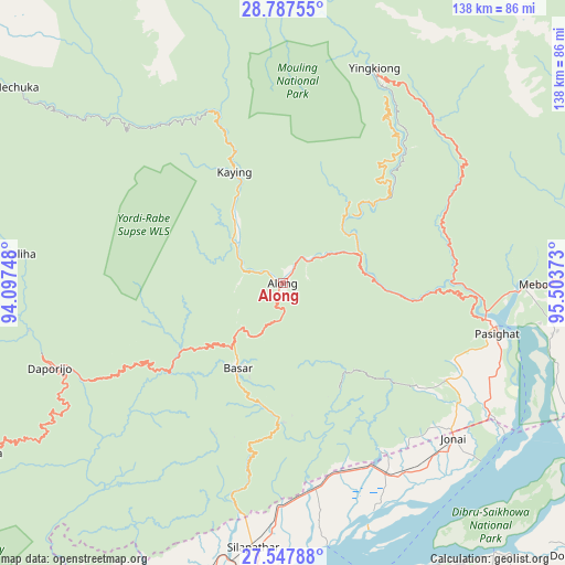
Along GPS coordinates[2]
28° 10' 10.236" North, 94° 48' 2.16" East
| Map corner | latitude | longitude |
|---|---|---|
| Upper-left | 28.78755°, | 94.09748° |
| Center: | 28.16951°, | 94.8006° |
| Lower-right: | 27.54788°, | 95.50373° |
| Map W x H: | 137.8×137.8 km | = 85.6×85.6mi |
| max Lat: | 34.9274° ⇑14.8% North |
| Along: | 28.16951° |
| min Lat: | ⇓85.2% South 8.09008° |
| min Long | Along | max Long |
| 68.82655° | 94.8006° | 96.81° |
| W 99.3%⇐ | ⇒0.7% E |
Elevation
Elevation of Along is 268 m = 879 ft, and this is 27.6 m = 91 ft below average elevation for this country.
| Max E: |
3681 m = 12077 ft | 37.5% |
| Avg. | 295.6 m = 970 ft | |
| Along | 268 m = 879 ft | |
Min E: |
1 m = 3 ft | 62.5% |
See also: India elevation on elevation.city.
Geographical zone
Along is located in North temperate zone (between Tropic of Cancer and the Arctic Circle). Distance of this Northern Tropic circle is 526.2 km =327 mi to South.| Distance of | km | miles | from Along |
|---|---|---|---|
| North Pole | 6874.9 | 4271.9 | to North |
| Arctic Circle | 4269 | 2652.6 | to North |
| Tropic Cancer | 526.2 | 327 | to South |
| Equator | 3132.2 | 1946.3 | to South |


Nearby cities:
15 places around Along: (largest is in red/bold)
• Bāsār
22.5 km =14 mi,  207°
207°
• Chābua
84.8 km =52.7 mi,  154°
154°
• Dhemāji
79.2 km =49.2 mi,  195°
195°
• Dibrugarh
77.4 km =48.1 mi,  172°
172°
• Digboi
118 km =73.3 mi,  137°
137°
• Duliāgaon
101.7 km =63.2 mi, 150°
• Dum Duma
99.9 km =62.1 mi,  131°
131°
• Morānha
109.8 km =68.2 mi, 174°
• Mākum
98.4 km =61.1 mi, 140°
• Nahorkatiya
111.4 km =69.2 mi, 151°
• Pangin
19 km =11.8 mi,  76°
76°
• Pāsighāt
52.9 km =32.9 mi,  102°
102°
• Silapathar
64.4 km =40 mi,  186°
186°
• Tinsukia
93.5 km =58.1 mi, 143°
• Ziro
114.1 km =70.9 mi,  235°
235°
Sources, notices
• [Note1] Compared only with cities in India existing in our database
• [Src1] Map data: © OpenStreetMap contributors (CC-BY-SA)
• [Src2] Other city data from geonames.org with taken over terms of usage.
• [Src3] Geographical zone / Annual Mean Temperature by Robert A. Rohde @ Wikipedia
