Buxar geodata
Buxar (Bihar) is a populated place; located in India in Asia/Kolkata (GMT+5.5) time zone. With population of 96,120 people, there are 462 cities with bigger population in this country. Compared to other cities in India, 67.5% of cities are located further ↓South; 81.9% of cities are located further ←West and 75.2% of cities have higher elevation than Buxar. Note1


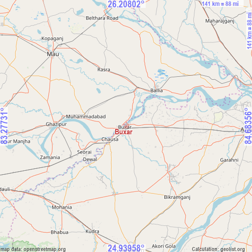
Buxar GPS coordinates[2]
25° 34' 31.728" North, 83° 58' 49.548" East
| Map corner | latitude | longitude |
|---|---|---|
| Upper-left | 26.20802°, | 83.27731° |
| Center: | 25.57548°, | 83.98043° |
| Lower-right: | 24.93958°, | 84.68356° |
| Map W x H: | 141×141 km | = 87.6×87.6mi |
| max Lat: | 34.9274° ⇑32.5% North |
| Buxar: | 25.57548° |
| min Lat: | ⇓67.5% South 8.09008° |
| min Long | Buxar | max Long |
| 68.82655° | 83.98043° | 96.81° |
| W 81.9%⇐ | ⇒18.1% E |
Elevation
Elevation of Buxar is 67 m = 220 ft, and this is 228.6 m = 750 ft below average elevation for this country.
| Max E: |
3681 m = 12077 ft | 75.2% |
| Avg. | 295.6 m = 970 ft | |
| Buxar | 67 m = 220 ft | |
Min E: |
1 m = 3 ft | 24.8% |
See also: Buxar elevation on elevation.city.
Geographical zone
Buxar is located in North temperate zone (between Tropic of Cancer and the Arctic Circle). Distance of this Northern Tropic circle is 237.8 km =147.8 mi to South.| Distance of | km | miles | from Buxar |
|---|---|---|---|
| North Pole | 7163.3 | 4451.1 | to North |
| Arctic Circle | 4557.4 | 2831.8 | to North |
| Tropic Cancer | 237.8 | 147.8 | to South |
| Equator | 2843.7 | 1767 | to South |


Nearby cities:
15 places around Buxar: (largest is in red/bold)
• Bikramganj
49.1 km =30.5 mi,  145°
145°
• Bānsdīh
41.7 km =25.9 mi,  34°
34°
• Dumraon
17.3 km =10.7 mi,  98°
98°
• Ghazīpur
39.6 km =24.6 mi,  271°
271°
• Jagdīspur
45.6 km =28.3 mi,  105°
105°
• Koāth
39.4 km =24.5 mi,  134°
134°
• Maniar
49.5 km =30.8 mi,  22°
22°
• Mau
58.5 km =36.4 mi,  314°
314°
• Muhammadābād
23 km =14.3 mi,  282°
282°
• Piro
50.4 km =31.3 mi,  122°
122°
• Rasrā
33.8 km =21 mi,  338°
338°
• Reoti
50.2 km =31.2 mi,  52°
52°
• Shāhpur
42.6 km =26.5 mi,  85°
85°
• Sikandarpur
52.5 km =32.6 mi,  7°
7°
• Zamānia
45.8 km =28.5 mi,  247°
247°
Sources, notices
• [Note1] Compared only with cities in India existing in our database
• [Src1] Map data: © OpenStreetMap contributors (CC-BY-SA)
• [Src2] Other city data from geonames.org with taken over terms of usage.
• [Src3] Geographical zone / Annual Mean Temperature by Robert A. Rohde @ Wikipedia
