Dumraon geodata
Dumraon (Bihar) is a populated place; located in India in Asia/Kolkata (GMT+5.5) time zone. With population of 50,524 people, there are 881 cities with bigger population in this country. Compared to other cities in India, 67.3% of cities are located further ↓South; 82.3% of cities are located further ←West and 73.6% of cities have higher elevation than Dumraon. Note1


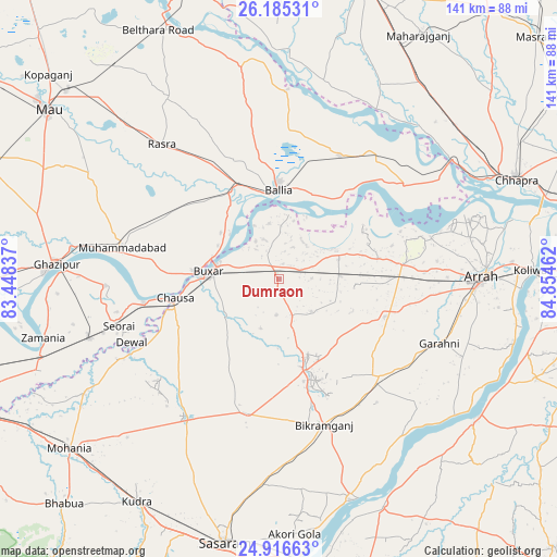
Dumraon GPS coordinates[2]
25° 33' 9.54" North, 84° 9' 5.364" East
| Map corner | latitude | longitude |
|---|---|---|
| Upper-left | 26.18531°, | 83.44837° |
| Center: | 25.55265°, | 84.15149° |
| Lower-right: | 24.91663°, | 84.85462° |
| Map W x H: | 141.1×141.1 km | = 87.7×87.7mi |
| max Lat: | 34.9274° ⇑32.7% North |
| Dumraon: | 25.55265° |
| min Lat: | ⇓67.3% South 8.09008° |
| min Long | Dumraon | max Long |
| 68.82655° | 84.15149° | 96.81° |
| W 82.3%⇐ | ⇒17.7% E |
Elevation
Elevation of Dumraon is 76 m = 249 ft, and this is 219.6 m = 720 ft below average elevation for this country.
| Max E: |
3681 m = 12077 ft | 73.6% |
| Avg. | 295.6 m = 970 ft | |
| Dumraon | 76 m = 249 ft | |
Min E: |
1 m = 3 ft | 26.4% |
See also: Dumraon elevation on elevation.city.
Geographical zone
Dumraon is located in North temperate zone (between Tropic of Cancer and the Arctic Circle). Distance of this Northern Tropic circle is 235.3 km =146.2 mi to South.| Distance of | km | miles | from Dumraon |
|---|---|---|---|
| North Pole | 7165.9 | 4452.7 | to North |
| Arctic Circle | 4560 | 2833.5 | to North |
| Tropic Cancer | 235.3 | 146.2 | to South |
| Equator | 2841.2 | 1765.4 | to South |


Nearby cities:
15 places around Dumraon: (largest is in red/bold)
• Arrah
51.3 km =31.9 mi,  89°
89°
• Bikramganj
39.4 km =24.5 mi,  164°
164°
• Buxar
17.3 km =10.7 mi,  278°
278°
• Bānsdīh
37.4 km =23.2 mi,  10°
10°
• Ghazīpur
56.9 km =35.4 mi,  273°
273°
• Jagdīspur
28.5 km =17.7 mi,  109°
109°
• Koāth
27.4 km =17 mi, 156°
• Maniar
48.2 km =30 mi,  2°
2°
• Muhammadābād
40.4 km =25.1 mi, 280°
• Piro
35.3 km =21.9 mi,  133°
133°
• Rasrā
45.1 km =28 mi,  318°
318°
• Reoti
40.2 km =25 mi,  34°
34°
• Revelganj
55.2 km =34.3 mi,  61°
61°
• Shāhpur
25.9 km =16.1 mi,  77°
77°
• Sikandarpur
55.4 km =34.4 mi,  349°
349°
Sources, notices
• [Note1] Compared only with cities in India existing in our database
• [Src1] Map data: © OpenStreetMap contributors (CC-BY-SA)
• [Src2] Other city data from geonames.org with taken over terms of usage.
• [Src3] Geographical zone / Annual Mean Temperature by Robert A. Rohde @ Wikipedia
