Homnābād geodata
Homnābād (Karnataka) is a populated place; located in India in Asia/Kolkata (GMT+5.5) time zone. With population of 41,485 people, there are 1067 cities with bigger population in this country. Compared to other cities in India, 72.3% of cities are located further ↑North; 61.7% of cities are located further →East and 90.2% of cities have lower elevation than Homnābād. Note1


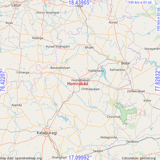
Homnābād GPS coordinates[2]
17° 46' 14.664" North, 77° 7' 30.684" East
| Map corner | latitude | longitude |
|---|---|---|
| Upper-left | 18.43905°, | 76.42207° |
| Center: | 17.77074°, | 77.12519° |
| Lower-right: | 17.09992°, | 77.82832° |
| Map W x H: | 148.9×148.9 km | = 92.5×92.5mi |
| max Lat: | 34.9274° ⇑72.3% North |
| Homnābād: | 17.77074° |
| min Lat: | ⇓27.7% South 8.09008° |
| min Long | Homnābād | max Long |
| 68.82655° | 77.12519° | 96.81° |
| W 38.3%⇐ | ⇒61.7% E |
Elevation
Elevation of Homnābād is 641 m = 2103 ft, and this is 345.4 m = 1133 ft above average elevation for this country.
| Max E: |
3681 m = 12077 ft | 9.8% |
| Homnābād | 641 m 2103 ft | |
| Avg. | 295.6 m = 970 ft | |
Min E: |
1 m = 3 ft | 90.2% |
See also: Homnābād elevation on elevation.city.
Geographical zone
Homnābād is located in North Torrid zone (between Equator and Tropic of Cancer). Distance of this Northern Tropic circle is 630 km =391.5 mi to North.| Distance of | km | miles | from Homnābād |
|---|---|---|---|
| North Pole | 8031.1 | 4990.3 | to North |
| Arctic Circle | 5425.3 | 3371.1 | to North |
| Tropic Cancer | 630 | 391.5 | to North |
| Equator | 1975.9 | 1227.8 | to South |


Nearby cities:
15 places around Homnābād: (largest is in red/bold)
• Aland
63.3 km =39.3 mi,  248°
248°
• Aurād
62 km =38.5 mi,  29°
29°
• Basavakalyān
21.9 km =13.6 mi,  301°
301°
• Bhālki
31.5 km =19.6 mi,  15°
15°
• Bīdar
45.7 km =28.4 mi,  69°
69°
• Chincholi
46.1 km =28.6 mi,  137°
137°
• Chītāpur
72.1 km =44.8 mi,  183°
183°
• Gulbarga
57.2 km =35.5 mi,  212°
212°
• Kurgunta
68.8 km =42.8 mi,  158°
158°
• Moram
69.3 km =43.1 mi,  271°
271°
• Nilanga
55.1 km =34.2 mi,  314°
314°
• Seram
68.1 km =42.3 mi,  165°
165°
• Udgīr
69.1 km =42.9 mi,  359°
359°
• Umarga
53.7 km =33.4 mi,  278°
278°
• Zahirābād
52 km =32.3 mi,  101°
101°
Sources, notices
• [Note1] Compared only with cities in India existing in our database
• [Src1] Map data: © OpenStreetMap contributors (CC-BY-SA)
• [Src2] Other city data from geonames.org with taken over terms of usage.
• [Src3] Geographical zone / Annual Mean Temperature by Robert A. Rohde @ Wikipedia
