Bīdar geodata
Bīdar (Karnataka) is a populated place; located in India in Asia/Kolkata (GMT+5.5) time zone. With population of 204,071 people, there are 204 cities with bigger population in this country. Compared to other cities in India, 72% of cities are located further ↑North; 57% of cities are located further →East and 91.8% of cities have lower elevation than Bīdar. Note1


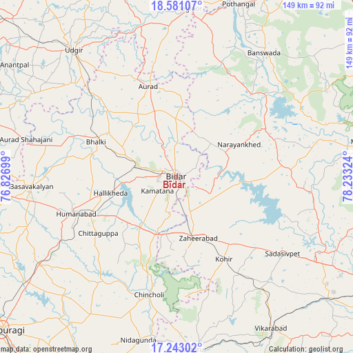
Bīdar GPS coordinates[2]
17° 54' 47.916" North, 77° 31' 48.396" East
| Map corner | latitude | longitude |
|---|---|---|
| Upper-left | 18.58107°, | 76.82699° |
| Center: | 17.91331°, | 77.53011° |
| Lower-right: | 17.24302°, | 78.23324° |
| Map W x H: | 148.8×148.8 km | = 92.5×92.5mi |
| max Lat: | 34.9274° ⇑72% North |
| Bīdar: | 17.91331° |
| min Lat: | ⇓28% South 8.09008° |
| min Long | Bīdar | max Long |
| 68.82655° | 77.53011° | 96.81° |
| W 43%⇐ | ⇒57% E |
Elevation
Elevation of Bīdar is 677 m = 2221 ft, and this is 381.4 m = 1251 ft above average elevation for this country.
| Max E: |
3681 m = 12077 ft | 8.2% |
| Bīdar | 677 m 2221 ft | |
| Avg. | 295.6 m = 970 ft | |
Min E: |
1 m = 3 ft | 91.8% |
See also: Bīdar elevation on elevation.city.
Geographical zone
Bīdar is located in North Torrid zone (between Equator and Tropic of Cancer). Distance of this Northern Tropic circle is 614.1 km =381.6 mi to North.| Distance of | km | miles | from Bīdar |
|---|---|---|---|
| North Pole | 8015.3 | 4980.5 | to North |
| Arctic Circle | 5409.4 | 3361.2 | to North |
| Tropic Cancer | 614.1 | 381.6 | to North |
| Equator | 1991.8 | 1237.6 | to South |


Nearby cities:
15 places around Bīdar: (largest is in red/bold)
• Andol
58.9 km =36.6 mi,  100°
100°
• Aurād
39.7 km =24.7 mi,  342°
342°
• Basavakalyān
61.6 km =38.3 mi,  265°
265°
• Bhālki
37.2 km =23.1 mi,  292°
292°
• Bānswāda
63.5 km =39.5 mi,  35°
35°
• Chandūr
60.5 km =37.6 mi,  94°
94°
• Chincholi
51.2 km =31.8 mi,  193°
193°
• Dīglūr
70.8 km =44 mi,  4°
4°
• Homnābād
45.7 km =28.4 mi,  249°
249°
• Sadāseopet
55.4 km =34.4 mi,  126°
126°
• Sangāreddi
67.1 km =41.7 mi,  118°
118°
• Tāndūr
74.1 km =46 mi,  176°
176°
• Udgīr
68.8 km =42.8 mi,  320°
320°
• Vikārābād
75.3 km =46.8 mi,  148°
148°
• Zahirābād
27.1 km =16.8 mi,  162°
162°
Sources, notices
• [Note1] Compared only with cities in India existing in our database
• [Src1] Map data: © OpenStreetMap contributors (CC-BY-SA)
• [Src2] Other city data from geonames.org with taken over terms of usage.
• [Src3] Geographical zone / Annual Mean Temperature by Robert A. Rohde @ Wikipedia
