Seram geodata
Seram (Karnataka) is a populated place; located in India in Asia/Kolkata (GMT+5.5) time zone. With population of 35,134 people, there are 1238 cities with bigger population in this country. Compared to other cities in India, 74.4% of cities are located further ↑North; 60% of cities are located further →East and 77.6% of cities have lower elevation than Seram. Note1


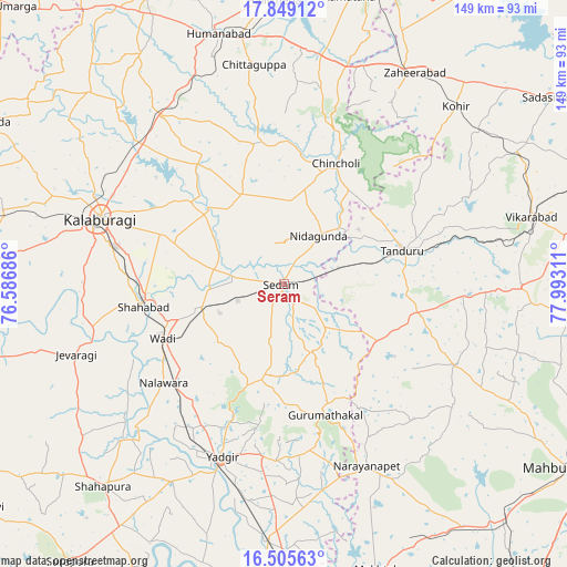
Seram GPS coordinates[2]
17° 10' 42.924" North, 77° 17' 23.928" East
| Map corner | latitude | longitude |
|---|---|---|
| Upper-left | 17.84912°, | 76.58686° |
| Center: | 17.17859°, | 77.28998° |
| Lower-right: | 16.50563°, | 77.99311° |
| Map W x H: | 149.4×149.4 km | = 92.8×92.8mi |
| max Lat: | 34.9274° ⇑74.4% North |
| Seram: | 17.17859° |
| min Lat: | ⇓25.6% South 8.09008° |
| min Long | Seram | max Long |
| 68.82655° | 77.28998° | 96.81° |
| W 40%⇐ | ⇒60% E |
Elevation
Elevation of Seram is 425 m = 1394 ft, and this is 129.4 m = 425 ft above average elevation for this country.
| Max E: |
3681 m = 12077 ft | 22.4% |
| Seram | 425 m 1394 ft | |
| Avg. | 295.6 m = 970 ft | |
Min E: |
1 m = 3 ft | 77.6% |
See also: India elevation on elevation.city.
Geographical zone
Seram is located in North Torrid zone (between Equator and Tropic of Cancer). Distance of this Northern Tropic circle is 695.8 km =432.3 mi to North.| Distance of | km | miles | from Seram |
|---|---|---|---|
| North Pole | 8097 | 5031.2 | to North |
| Arctic Circle | 5491.1 | 3412 | to North |
| Tropic Cancer | 695.8 | 432.3 | to North |
| Equator | 1910.1 | 1186.9 | to South |


Nearby cities:
15 places around Seram: (largest is in red/bold)
• Chincholi
34.7 km =21.6 mi,  23°
23°
• Chītāpur
22.9 km =14.2 mi,  254°
254°
• Gulbarga
51.1 km =31.8 mi,  289°
289°
• Gurmatkāl
36.2 km =22.5 mi,  162°
162°
• Homnābād
68.1 km =42.3 mi,  345°
345°
• Jevargi
57.9 km =36 mi, 251°
• Kurgunta
7.4 km =4.6 mi,  77°
77°
• Nārāyanpet
52.6 km =32.7 mi, 155°
• Shāhpur
71.7 km =44.6 mi,  221°
221°
• Shāhābād
37.2 km =23.1 mi,  261°
261°
• Tāndūr
31.5 km =19.6 mi, 75°
• Vikārābād
67.6 km =42 mi,  74°
74°
• Wādi
34.8 km =21.6 mi, 246°
• Yādgīr
48.2 km =30 mi,  199°
199°
• Zahirābād
65.3 km =40.6 mi,  31°
31°
Sources, notices
• [Note1] Compared only with cities in India existing in our database
• [Src1] Map data: © OpenStreetMap contributors (CC-BY-SA)
• [Src2] Other city data from geonames.org with taken over terms of usage.
• [Src3] Geographical zone / Annual Mean Temperature by Robert A. Rohde @ Wikipedia
