Hindaun geodata
Hindaun (Rajasthan) is a populated place; located in India in Asia/Kolkata (GMT+5.5) time zone. With population of 95,593 people, there are 466 cities with bigger population in this country. Compared to other cities in India, 76.2% of cities are located further ↓South; 62.7% of cities are located further →East and 56.2% of cities have lower elevation than Hindaun. Note1


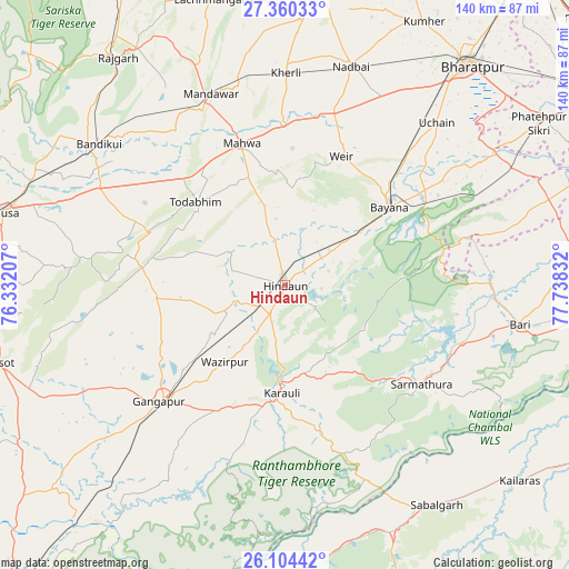
Hindaun GPS coordinates[2]
26° 44' 2.796" North, 77° 2' 6.684" East
| Map corner | latitude | longitude |
|---|---|---|
| Upper-left | 27.36033°, | 76.33207° |
| Center: | 26.73411°, | 77.03519° |
| Lower-right: | 26.10442°, | 77.73832° |
| Map W x H: | 139.6×139.6 km | = 86.7×86.7mi |
| max Lat: | 34.9274° ⇑23.8% North |
| Hindaun: | 26.73411° |
| min Lat: | ⇓76.2% South 8.09008° |
| min Long | Hindaun | max Long |
| 68.82655° | 77.03519° | 96.81° |
| W 37.3%⇐ | ⇒62.7% E |
Elevation
Elevation of Hindaun is 231 m = 758 ft, and this is 64.6 m = 212 ft below average elevation for this country.
| Max E: |
3681 m = 12077 ft | 43.8% |
| Avg. | 295.6 m = 970 ft | |
| Hindaun | 231 m = 758 ft | |
Min E: |
1 m = 3 ft | 56.2% |
See also: Hindaun elevation on elevation.city.
Geographical zone
Hindaun is located in North temperate zone (between Tropic of Cancer and the Arctic Circle). Distance of this Northern Tropic circle is 366.6 km =227.8 mi to South.| Distance of | km | miles | from Hindaun |
|---|---|---|---|
| North Pole | 7034.5 | 4371 | to North |
| Arctic Circle | 4428.6 | 2751.8 | to North |
| Tropic Cancer | 366.6 | 227.8 | to South |
| Equator | 2972.6 | 1847.1 | to South |


Nearby cities:
15 places around Hindaun: (largest is in red/bold)
• Abhaneri
52.2 km =32.4 mi,  305°
305°
• Baswa
64.3 km =40 mi,  315°
315°
• Bayāna
31.8 km =19.8 mi,  52°
52°
• Bhasāwar
33.9 km =21.1 mi,  2°
2°
• Bāndīkūi
57.8 km =35.9 mi, 307°
• Bāri
58.5 km =36.4 mi,  99°
99°
• Gangāpur
42.9 km =26.7 mi,  227°
227°
• Jagnair
58.1 km =36.1 mi,  75°
75°
• Karauli
26.2 km =16.3 mi,  181°
181°
• Mahwah
36.2 km =22.5 mi,  343°
343°
• Nādbai
56.6 km =35.2 mi,  16°
16°
• Rājgarh
69.3 km =43.1 mi, 323°
• Sabalgarh
65.4 km =40.6 mi,  145°
145°
• Todabhim
29.7 km =18.5 mi, 313°
• Wer
34.6 km =21.5 mi, 23°
Sources, notices
• [Note1] Compared only with cities in India existing in our database
• [Src1] Map data: © OpenStreetMap contributors (CC-BY-SA)
• [Src2] Other city data from geonames.org with taken over terms of usage.
• [Src3] Geographical zone / Annual Mean Temperature by Robert A. Rohde @ Wikipedia
