Manalūrpettai geodata
Manalūrpettai (Tamil Nadu) is a populated place; located in India in Asia/Kolkata (GMT+5.5) time zone. With population of 7,626 people, there are 3154 cities with bigger population in this country. Compared to other cities in India, 89.7% of cities are located further ↑North; 59.7% of cities are located further ←West and 64.7% of cities have higher elevation than Manalūrpettai. Note1


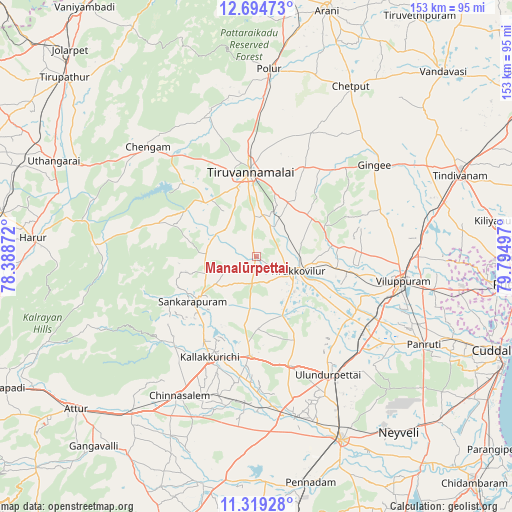
Manalūrpettai GPS coordinates[2]
12° 0' 28.368" North, 79° 5' 30.624" East
| Map corner | latitude | longitude |
|---|---|---|
| Upper-left | 12.69473°, | 78.38872° |
| Center: | 12.00788°, | 79.09184° |
| Lower-right: | 11.31928°, | 79.79497° |
| Map W x H: | 152.9×152.9 km | = 95×95mi |
| max Lat: | 34.9274° ⇑89.7% North |
| Manalūrpettai: | 12.00788° |
| min Lat: | ⇓10.3% South 8.09008° |
| min Long | Manalūrpettai | max Long |
| 68.82655° | 79.09184° | 96.81° |
| W 59.7%⇐ | ⇒40.3% E |
Elevation
Elevation of Manalūrpettai is 122 m = 400 ft, and this is 173.6 m = 570 ft below average elevation for this country.
| Max E: |
3681 m = 12077 ft | 64.7% |
| Avg. | 295.6 m = 970 ft | |
| Manalūrpettai | 122 m = 400 ft | |
Min E: |
1 m = 3 ft | 35.3% |
See also: India elevation on elevation.city.
Geographical zone
Manalūrpettai is located in North Torrid zone (between Equator and Tropic of Cancer). Distance of this Northern Tropic circle is 1270.8 km =789.6 mi to North.| Distance of | km | miles | from Manalūrpettai |
|---|---|---|---|
| North Pole | 8671.9 | 5388.5 | to North |
| Arctic Circle | 6066 | 3769.2 | to North |
| Tropic Cancer | 1270.8 | 789.6 | to North |
| Equator | 1335.2 | 829.7 | to South |


Nearby cities:
15 places around Manalūrpettai: (largest is in red/bold)
• Alagāpuram
23.2 km =14.4 mi,  234°
234°
• Chengam
46.8 km =29.1 mi,  315°
315°
• Chinna Salem
47.8 km =29.7 mi,  209°
209°
• Gingee
44.6 km =27.7 mi,  52°
52°
• Kallakkurichchi
33.1 km =20.6 mi, 205°
• Nangilickondan
49.9 km =31 mi,  56°
56°
• Panruti
56.4 km =35 mi,  117°
117°
• Pennāthur
30.3 km =18.8 mi,  28°
28°
• Polūr
56.2 km =34.9 mi,  3°
3°
• Tirukkoyilur
12.9 km =8 mi,  111°
111°
• Tiruvannāmalai
24.4 km =15.2 mi,  355°
355°
• Valavanur
54.2 km =33.7 mi,  100°
100°
• Vettavalam
20 km =12.4 mi, 56°
• Vikravāndi
49.5 km =30.8 mi,  86°
86°
• Villupuram
44.2 km =27.5 mi, 99°
Sources, notices
• [Note1] Compared only with cities in India existing in our database
• [Src1] Map data: © OpenStreetMap contributors (CC-BY-SA)
• [Src2] Other city data from geonames.org with taken over terms of usage.
• [Src3] Geographical zone / Annual Mean Temperature by Robert A. Rohde @ Wikipedia
