Tiruvannāmalai geodata
Tiruvannāmalai (Tamil Nadu) is a populated place; located in India in Asia/Kolkata (GMT+5.5) time zone. With population of 138,243 people, there are 315 cities with bigger population in this country. Compared to other cities in India, 89.2% of cities are located further ↑North; 59.6% of cities are located further ←West and 55.1% of cities have higher elevation than Tiruvannāmalai. Note1


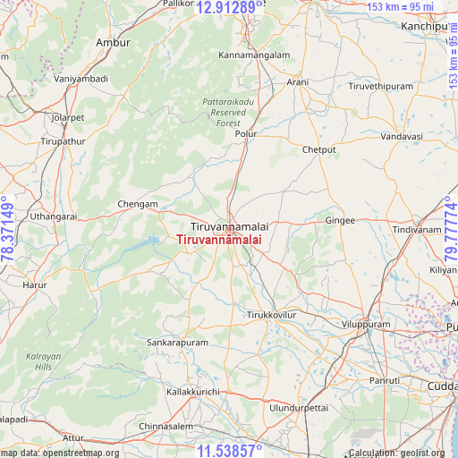
Tiruvannāmalai GPS coordinates[2]
12° 13' 35.832" North, 79° 4' 28.596" East
| Map corner | latitude | longitude |
|---|---|---|
| Upper-left | 12.91289°, | 78.37149° |
| Center: | 12.22662°, | 79.07461° |
| Lower-right: | 11.53857°, | 79.77774° |
| Map W x H: | 152.8×152.8 km | = 94.9×94.9mi |
| max Lat: | 34.9274° ⇑89.2% North |
| Tiruvannāmalai: | 12.22662° |
| min Lat: | ⇓10.8% South 8.09008° |
| min Long | Tiruvannāmalai | max Long |
| 68.82655° | 79.07461° | 96.81° |
| W 59.6%⇐ | ⇒40.4% E |
Elevation
Elevation of Tiruvannāmalai is 174 m = 571 ft, and this is 121.6 m = 399 ft below average elevation for this country.
| Max E: |
3681 m = 12077 ft | 55.1% |
| Avg. | 295.6 m = 970 ft | |
| Tiruvannāmalai | 174 m = 571 ft | |
Min E: |
1 m = 3 ft | 44.9% |
See also: Tiruvannāmalai elevation on elevation.city.
Geographical zone
Tiruvannāmalai is located in North Torrid zone (between Equator and Tropic of Cancer). Distance of this Northern Tropic circle is 1246.4 km =774.5 mi to North.| Distance of | km | miles | from Tiruvannāmalai |
|---|---|---|---|
| North Pole | 8647.6 | 5373.4 | to North |
| Arctic Circle | 6041.7 | 3754.1 | to North |
| Tropic Cancer | 1246.4 | 774.5 | to North |
| Equator | 1359.5 | 844.8 | to South |


Nearby cities:
15 places around Tiruvannāmalai: (largest is in red/bold)
• Alagāpuram
41.4 km =25.7 mi,  204°
204°
• Arni
54.1 km =33.6 mi,  25°
25°
• Chengam
32.1 km =19.9 mi,  286°
286°
• Desūr
50 km =31.1 mi,  62°
62°
• Gingee
37.3 km =23.2 mi,  85°
85°
• Kallakkurichchi
55.5 km =34.5 mi,  193°
193°
• Manalūrpettai
24.4 km =15.2 mi,  175°
175°
• Nangilickondan
43.6 km =27.1 mi, 85°
• Pennāthur
16.6 km =10.3 mi,  82°
82°
• Peranamallūr
54.6 km =33.9 mi,  45°
45°
• Polūr
32.2 km =20 mi,  9°
9°
• Tirukkoyilur
32.1 km =19.9 mi,  154°
154°
• Vettavalam
22.8 km =14.2 mi,  125°
125°
• Vikravāndi
55.4 km =34.4 mi,  112°
112°
• Villupuram
55.5 km =34.5 mi, 125°
Sources, notices
• [Note1] Compared only with cities in India existing in our database
• [Src1] Map data: © OpenStreetMap contributors (CC-BY-SA)
• [Src2] Other city data from geonames.org with taken over terms of usage.
• [Src3] Geographical zone / Annual Mean Temperature by Robert A. Rohde @ Wikipedia
