Botād geodata
Botād (Gujarat) is a seat of a second-order administrative division; located in India in Asia/Kolkata (GMT+5.5) time zone. With population of 117,053 people, there are 378 cities with bigger population in this country. Compared to other cities in India, 55.6% of cities are located further ↑North; 97.8% of cities are located further →East and 70.8% of cities have higher elevation than Botād. Note1


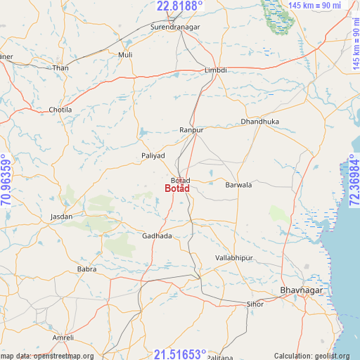
Botād GPS coordinates[2]
22° 10' 9.012" North, 71° 40' 0.156" East
| Map corner | latitude | longitude |
|---|---|---|
| Upper-left | 22.8188°, | 70.96359° |
| Center: | 22.16917°, | 71.66671° |
| Lower-right: | 21.51653°, | 72.36984° |
| Map W x H: | 144.8×144.8 km | = 90×90mi |
| max Lat: | 34.9274° ⇑55.6% North |
| Botād: | 22.16917° |
| min Lat: | ⇓44.4% South 8.09008° |
| min Long | Botād | max Long |
| 68.82655° | 71.66671° | 96.81° |
| W 2.2%⇐ | ⇒97.8% E |
Elevation
Elevation of Botād is 89 m = 292 ft, and this is 206.6 m = 678 ft below average elevation for this country.
| Max E: |
3681 m = 12077 ft | 70.8% |
| Avg. | 295.6 m = 970 ft | |
| Botād | 89 m = 292 ft | |
Min E: |
1 m = 3 ft | 29.2% |
See also: Botād elevation on elevation.city.
Geographical zone
Botād is located in North Torrid zone (between Equator and Tropic of Cancer). Distance of this Northern Tropic circle is 140.9 km =87.6 mi to North.| Distance of | km | miles | from Botād |
|---|---|---|---|
| North Pole | 7542.1 | 4686.4 | to North |
| Arctic Circle | 4936.2 | 3067.2 | to North |
| Tropic Cancer | 140.9 | 87.6 | to North |
| Equator | 2465 | 1531.7 | to South |


Nearby cities:
15 places around Botād: (largest is in red/bold)
• Bābra
51.8 km =32.2 mi,  226°
226°
• Chotila
56 km =34.8 mi,  300°
300°
• Dhandhuka
40.5 km =25.2 mi,  54°
54°
• Dhola
33.8 km =21 mi,  161°
161°
• Dāmnagar
55.2 km =34.3 mi,  196°
196°
• Gadhada
24 km =14.9 mi, 202°
• Jasdan
49.5 km =30.8 mi,  252°
252°
• Limbdi
46.4 km =28.8 mi,  18°
18°
• Lāthi
57.3 km =35.6 mi,  210°
210°
• Pāliyād
14.7 km =9.1 mi,  311°
311°
• Sihor
59.3 km =36.8 mi,  149°
149°
• Sāyla
46.3 km =28.8 mi,  335°
335°
• Umrāla
38.8 km =24.1 mi, 158°
• Valabhīpur
38.1 km =23.7 mi,  144°
144°
• Vinchia
29.9 km =18.6 mi,  278°
278°
Sources, notices
• [Note1] Compared only with cities in India existing in our database
• [Src1] Map data: © OpenStreetMap contributors (CC-BY-SA)
• [Src2] Other city data from geonames.org with taken over terms of usage.
• [Src3] Geographical zone / Annual Mean Temperature by Robert A. Rohde @ Wikipedia
