Tharād geodata
Tharād (Gujarat) is a populated place; located in India in Asia/Kolkata (GMT+5.5) time zone. With population of 24,697 people, there are 1723 cities with bigger population in this country. Compared to other cities in India, 60% of cities are located further ↓South; 97.9% of cities are located further →East and 78.5% of cities have higher elevation than Tharād. Note1


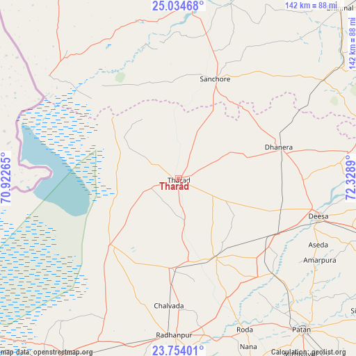
Tharād GPS coordinates[2]
24° 23' 45.492" North, 71° 37' 32.772" East
| Map corner | latitude | longitude |
|---|---|---|
| Upper-left | 25.03468°, | 70.92265° |
| Center: | 24.39597°, | 71.62577° |
| Lower-right: | 23.75401°, | 72.3289° |
| Map W x H: | 142.4×142.4 km | = 88.5×88.5mi |
| max Lat: | 34.9274° ⇑40% North |
| Tharād: | 24.39597° |
| min Lat: | ⇓60% South 8.09008° |
| min Long | Tharād | max Long |
| 68.82655° | 71.62577° | 96.81° |
| W 2.1%⇐ | ⇒97.9% E |
Elevation
Elevation of Tharād is 53 m = 174 ft, and this is 242.6 m = 796 ft below average elevation for this country.
| Max E: |
3681 m = 12077 ft | 78.5% |
| Avg. | 295.6 m = 970 ft | |
| Tharād | 53 m = 174 ft | |
Min E: |
1 m = 3 ft | 21.5% |
See also: India elevation on elevation.city.
Geographical zone
Tharād is located in North temperate zone (between Tropic of Cancer and the Arctic Circle). Distance of this Northern Tropic circle is 106.7 km =66.3 mi to South.| Distance of | km | miles | from Tharād |
|---|---|---|---|
| North Pole | 7294.5 | 4532.6 | to North |
| Arctic Circle | 4688.6 | 2913.4 | to North |
| Tropic Cancer | 106.7 | 66.3 | to South |
| Equator | 2712.6 | 1685.5 | to South |


Nearby cities:
15 places around Tharād: (largest is in red/bold)
• Bhīnmāl
93.6 km =58.2 mi,  44°
44°
• Chānasma
90.5 km =56.2 mi,  146°
146°
• Dhanera
42.2 km =26.2 mi,  72°
72°
• Dīsa
58.2 km =36.2 mi,  105°
105°
• Hārij
83.2 km =51.7 mi,  159°
159°
• Kherālu
115.6 km =71.8 mi,  119°
119°
• Kānodar
85 km =52.8 mi, 113°
• Pālanpur
86.1 km =53.5 mi, 106°
• Pātan
79.3 km =49.3 mi,  139°
139°
• Rādhanpur
62.7 km =39 mi,  181°
181°
• Siddhapur
92.5 km =57.5 mi,  125°
125°
• Sānchor
42.5 km =26.4 mi,  20°
20°
• Un
58.4 km =36.3 mi,  165°
165°
• Unjha
101.8 km =63.3 mi, 130°
• Ābu
112.6 km =70 mi,  78°
78°
Sources, notices
• [Note1] Compared only with cities in India existing in our database
• [Src1] Map data: © OpenStreetMap contributors (CC-BY-SA)
• [Src2] Other city data from geonames.org with taken over terms of usage.
• [Src3] Geographical zone / Annual Mean Temperature by Robert A. Rohde @ Wikipedia
