Dhanera geodata
Dhanera (Gujarat) is a populated place; located in India in Asia/Kolkata (GMT+5.5) time zone. With population of 23,656 people, there are 1790 cities with bigger population in this country. Compared to other cities in India, 60.7% of cities are located further ↓South; 97.4% of cities are located further →East and 62.1% of cities have higher elevation than Dhanera. Note1


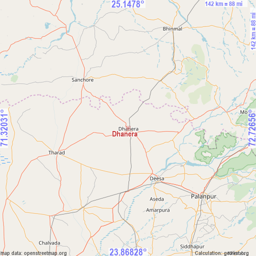
Dhanera GPS coordinates[2]
24° 30' 34.812" North, 72° 1' 24.348" East
| Map corner | latitude | longitude |
|---|---|---|
| Upper-left | 25.1478°, | 71.32031° |
| Center: | 24.50967°, | 72.02343° |
| Lower-right: | 23.86828°, | 72.72656° |
| Map W x H: | 142.3×142.3 km | = 88.4×88.4mi |
| max Lat: | 34.9274° ⇑39.3% North |
| Dhanera: | 24.50967° |
| min Lat: | ⇓60.7% South 8.09008° |
| min Long | Dhanera | max Long |
| 68.82655° | 72.02343° | 96.81° |
| W 2.6%⇐ | ⇒97.4% E |
Elevation
Elevation of Dhanera is 137 m = 449 ft, and this is 158.6 m = 520 ft below average elevation for this country.
| Max E: |
3681 m = 12077 ft | 62.1% |
| Avg. | 295.6 m = 970 ft | |
| Dhanera | 137 m = 449 ft | |
Min E: |
1 m = 3 ft | 37.9% |
See also: India elevation on elevation.city.
Geographical zone
Dhanera is located in North temperate zone (between Tropic of Cancer and the Arctic Circle). Distance of this Northern Tropic circle is 119.3 km =74.1 mi to South.| Distance of | km | miles | from Dhanera |
|---|---|---|---|
| North Pole | 7281.8 | 4524.7 | to North |
| Arctic Circle | 4676 | 2905.5 | to North |
| Tropic Cancer | 119.3 | 74.1 | to South |
| Equator | 2725.2 | 1693.4 | to South |


Nearby cities:
15 places around Dhanera: (largest is in red/bold)
• Bhīnmāl
59.9 km =37.2 mi,  24°
24°
• Chānasma
88.9 km =55.2 mi,  174°
174°
• Dīsa
32.3 km =20.1 mi,  150°
150°
• Hārij
91.5 km =56.9 mi,  187°
187°
• Kānodar
59.9 km =37.2 mi,  141°
141°
• Pālanpur
56.4 km =35 mi,  131°
131°
• Pātan
74.1 km =46 mi, 171°
• Rādhanpur
86.5 km =53.7 mi,  209°
209°
• Siddhapur
74.7 km =46.4 mi, 151°
• Sānchor
37.1 km =23.1 mi,  316°
316°
• Tharād
42.2 km =26.2 mi,  252°
252°
• Un
73.8 km =45.9 mi,  200°
200°
• Unjha
86.9 km =54 mi, 154°
• Ābu
70.8 km =44 mi,  82°
82°
• Ābu Road
76.8 km =47.7 mi,  92°
92°
Sources, notices
• [Note1] Compared only with cities in India existing in our database
• [Src1] Map data: © OpenStreetMap contributors (CC-BY-SA)
• [Src2] Other city data from geonames.org with taken over terms of usage.
• [Src3] Geographical zone / Annual Mean Temperature by Robert A. Rohde @ Wikipedia
