Gīdam geodata
Gīdam (Chhattisgarh) is a populated place; located in India in Asia/Kolkata (GMT+5.5) time zone. With population of 6,228 people, there are 3268 cities with bigger population in this country. Compared to other cities in India, 68.7% of cities are located further ↑North; 74.3% of cities are located further ←West and 75.8% of cities have lower elevation than Gīdam. Note1


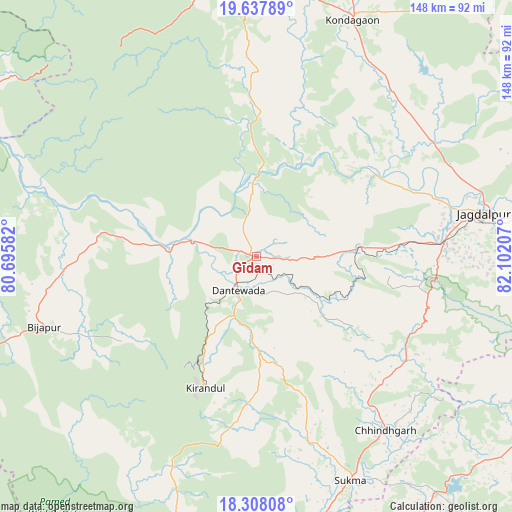
Gīdam GPS coordinates[2]
18° 58' 27.516" North, 81° 23' 56.184" East
| Map corner | latitude | longitude |
|---|---|---|
| Upper-left | 19.63789°, | 80.69582° |
| Center: | 18.97431°, | 81.39894° |
| Lower-right: | 18.30808°, | 82.10207° |
| Map W x H: | 147.9×147.9 km | = 91.9×91.9mi |
| max Lat: | 34.9274° ⇑68.7% North |
| Gīdam: | 18.97431° |
| min Lat: | ⇓31.3% South 8.09008° |
| min Long | Gīdam | max Long |
| 68.82655° | 81.39894° | 96.81° |
| W 74.3%⇐ | ⇒25.7% E |
Elevation
Elevation of Gīdam is 396 m = 1299 ft, and this is 100.4 m = 329 ft above average elevation for this country.
| Max E: |
3681 m = 12077 ft | 24.2% |
| Gīdam | 396 m 1299 ft | |
| Avg. | 295.6 m = 970 ft | |
Min E: |
1 m = 3 ft | 75.8% |
See also: India elevation on elevation.city.
Geographical zone
Gīdam is located in North Torrid zone (between Equator and Tropic of Cancer). Distance of this Northern Tropic circle is 496.2 km =308.3 mi to North.| Distance of | km | miles | from Gīdam |
|---|---|---|---|
| North Pole | 7897.3 | 4907.2 | to North |
| Arctic Circle | 5291.4 | 3287.9 | to North |
| Tropic Cancer | 496.2 | 308.3 | to North |
| Equator | 2109.7 | 1310.9 | to South |


Nearby cities:
15 places around Gīdam: (largest is in red/bold)
• Allāpalli
149.1 km =92.6 mi,  289°
289°
• Balimila
109.6 km =68.1 mi,  137°
137°
• Chittarkonda
120.5 km =74.9 mi, 141°
• Jagdalpur
66.5 km =41.3 mi,  79°
79°
• Jeypore
124 km =77.1 mi,  96°
96°
• Kirandul
40.4 km =25.1 mi,  201°
201°
• Kondagaon
74 km =46 mi,  22°
22°
• Korāput
139.1 km =86.4 mi, 97°
• Kotapārh
99.1 km =61.6 mi, 79°
• Kānker
144.6 km =89.9 mi,  3°
3°
• Malakanagiri
85.2 km =52.9 mi, 142°
• Manuguru
129.7 km =80.6 mi,  211°
211°
• Nowrangapur
124.1 km =77.1 mi, 76°
• Sukma
70.5 km =43.8 mi,  157°
157°
• Umarkot
114.4 km =71.1 mi,  47°
47°
Sources, notices
• [Note1] Compared only with cities in India existing in our database
• [Src1] Map data: © OpenStreetMap contributors (CC-BY-SA)
• [Src2] Other city data from geonames.org with taken over terms of usage.
• [Src3] Geographical zone / Annual Mean Temperature by Robert A. Rohde @ Wikipedia
