Jasrāna geodata
Jasrāna (Uttar Pradesh) is a populated place; located in India in Asia/Kolkata (GMT+5.5) time zone. With population of 9,883 people, there are 2960 cities with bigger population in this country. Compared to other cities in India, 80.4% of cities are located further ↓South; 55.6% of cities are located further ←West and 56.4% of cities have higher elevation than Jasrāna. Note1


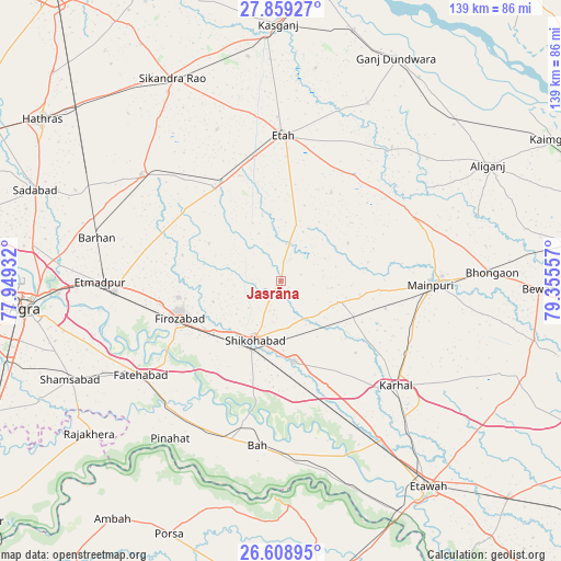
Jasrāna GPS coordinates[2]
27° 14' 9.132" North, 78° 39' 8.784" East
| Map corner | latitude | longitude |
|---|---|---|
| Upper-left | 27.85927°, | 77.94932° |
| Center: | 27.23587°, | 78.65244° |
| Lower-right: | 26.60895°, | 79.35557° |
| Map W x H: | 139×139 km | = 86.4×86.4mi |
| max Lat: | 34.9274° ⇑19.6% North |
| Jasrāna: | 27.23587° |
| min Lat: | ⇓80.4% South 8.09008° |
| min Long | Jasrāna | max Long |
| 68.82655° | 78.65244° | 96.81° |
| W 55.6%⇐ | ⇒44.4% E |
Elevation
Elevation of Jasrāna is 168 m = 551 ft, and this is 127.6 m = 419 ft below average elevation for this country.
| Max E: |
3681 m = 12077 ft | 56.4% |
| Avg. | 295.6 m = 970 ft | |
| Jasrāna | 168 m = 551 ft | |
Min E: |
1 m = 3 ft | 43.6% |
See also: India elevation on elevation.city.
Geographical zone
Jasrāna is located in North temperate zone (between Tropic of Cancer and the Arctic Circle). Distance of this Northern Tropic circle is 422.4 km =262.5 mi to South.| Distance of | km | miles | from Jasrāna |
|---|---|---|---|
| North Pole | 6978.7 | 4336.4 | to North |
| Arctic Circle | 4372.8 | 2717.1 | to North |
| Tropic Cancer | 422.4 | 262.5 | to South |
| Equator | 3028.3 | 1881.7 | to South |


Nearby cities:
15 places around Jasrāna: (largest is in red/bold)
• Bāh
41.2 km =25.6 mi,  188°
188°
• Fatehābād
41.7 km =25.9 mi,  236°
236°
• Fīrozābād
26.9 km =16.7 mi,  249°
249°
• Ghiror
14.9 km =9.3 mi,  110°
110°
• Itimādpur
44.9 km =27.9 mi,  269°
269°
• Jalesar
43.4 km =27 mi,  307°
307°
• Jaswantnagar
46.4 km =28.8 mi,  147°
147°
• Karhal
38.6 km =24 mi,  132°
132°
• Mainpuri
37.2 km =23.1 mi,  91°
91°
• Pharihā
20.2 km =12.6 mi,  298°
298°
• Pināhat
47.6 km =29.6 mi,  214°
214°
• Sakīt
25.4 km =15.8 mi,  29°
29°
• Shikohābād
15.6 km =9.7 mi,  204°
204°
• Sirsāganj
20.2 km =12.6 mi,  170°
170°
• Tūndla
41.2 km =25.6 mi, 266°
Sources, notices
• [Note1] Compared only with cities in India existing in our database
• [Src1] Map data: © OpenStreetMap contributors (CC-BY-SA)
• [Src2] Other city data from geonames.org with taken over terms of usage.
• [Src3] Geographical zone / Annual Mean Temperature by Robert A. Rohde @ Wikipedia
