Alīpur Duār geodata
Alīpur Duār (West Bengal) is a seat of a second-order administrative division; located in India in Asia/Kolkata (GMT+5.5) time zone. With population of 65,232 people, there are 672 cities with bigger population in this country. Compared to other cities in India, 74.5% of cities are located further ↓South; 95.4% of cities are located further ←West and 79.7% of cities have higher elevation than Alīpur Duār. Note1


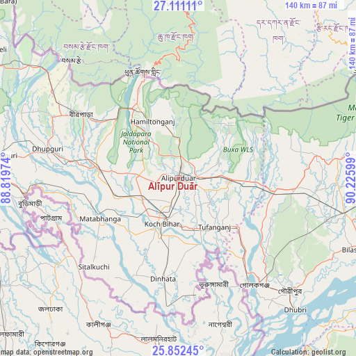
Alīpur Duār GPS coordinates[2]
26° 29' 0.6" North, 89° 31' 22.296" East
| Map corner | latitude | longitude |
|---|---|---|
| Upper-left | 27.11111°, | 88.81974° |
| Center: | 26.4835°, | 89.52286° |
| Lower-right: | 25.85245°, | 90.22599° |
| Map W x H: | 139.9×140 km | = 86.9×87mi |
| max Lat: | 34.9274° ⇑25.5% North |
| Alīpur Duār: | 26.4835° |
| min Lat: | ⇓74.5% South 8.09008° |
| min Long | Alīpur Duār | max Long |
| 68.82655° | 89.52286° | 96.81° |
| W 95.4%⇐ | ⇒4.6% E |
Elevation
Elevation of Alīpur Duār is 49 m = 161 ft, and this is 246.6 m = 809 ft below average elevation for this country.
| Max E: |
3681 m = 12077 ft | 79.7% |
| Avg. | 295.6 m = 970 ft | |
| Alīpur Duār | 49 m = 161 ft | |
Min E: |
1 m = 3 ft | 20.3% |
See also: Alīpur Duār elevation on elevation.city.
Geographical zone
Alīpur Duār is located in North temperate zone (between Tropic of Cancer and the Arctic Circle). Distance of this Northern Tropic circle is 338.8 km =210.5 mi to South.| Distance of | km | miles | from Alīpur Duār |
|---|---|---|---|
| North Pole | 7062.4 | 4388.4 | to North |
| Arctic Circle | 4456.5 | 2769.1 | to North |
| Tropic Cancer | 338.8 | 210.5 | to South |
| Equator | 2944.7 | 1829.8 | to South |


Nearby cities:
15 places around Alīpur Duār: (largest is in red/bold)
• Birpara
44.8 km =27.8 mi,  303°
303°
• Dhupgāri
52.6 km =32.7 mi,  282°
282°
• Dīnhāta
39.2 km =24.4 mi,  189°
189°
• Fālākāta
32 km =19.9 mi, 277°
• Gauripur
62.4 km =38.8 mi,  135°
135°
• Golakganj
51.9 km =32.2 mi, 144°
• Goshaingaon
44.1 km =27.4 mi,  96°
96°
• Goyerkāta
55 km =34.2 mi, 295°
• Hāsimāra
33.8 km =21 mi,  330°
330°
• Jaigaon
43.1 km =26.8 mi,  340°
340°
• Koch Bihār
19.2 km =11.9 mi,  203°
203°
• Latabāri
38.7 km =24 mi,  120°
120°
• Mātābhānga
34.4 km =21.4 mi,  242°
242°
• Sapatgrām
62 km =38.5 mi,  105°
105°
• Tufānganj
23.3 km =14.5 mi, 142°
Sources, notices
• [Note1] Compared only with cities in India existing in our database
• [Src1] Map data: © OpenStreetMap contributors (CC-BY-SA)
• [Src2] Other city data from geonames.org with taken over terms of usage.
• [Src3] Geographical zone / Annual Mean Temperature by Robert A. Rohde @ Wikipedia
