Tonk geodata
Tonk (Rajasthan) is a populated place; located in India in Asia/Kolkata (GMT+5.5) time zone. With population of 151,331 people, there are 291 cities with bigger population in this country. Compared to other cities in India, 71.7% of cities are located further ↓South; 75.8% of cities are located further →East and 63.9% of cities have lower elevation than Tonk. Note1


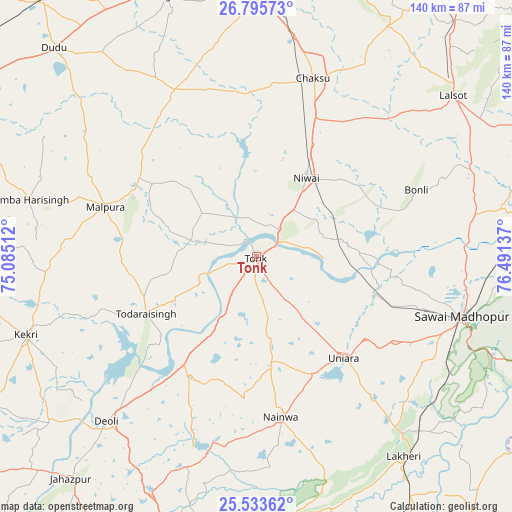
Tonk GPS coordinates[2]
26° 9' 58.968" North, 75° 47' 17.664" East
| Map corner | latitude | longitude |
|---|---|---|
| Upper-left | 26.79573°, | 75.08512° |
| Center: | 26.16638°, | 75.78824° |
| Lower-right: | 25.53362°, | 76.49137° |
| Map W x H: | 140.3×140.3 km | = 87.2×87.2mi |
| max Lat: | 34.9274° ⇑28.3% North |
| Tonk: | 26.16638° |
| min Lat: | ⇓71.7% South 8.09008° |
| min Long | Tonk | max Long |
| 68.82655° | 75.78824° | 96.81° |
| W 24.2%⇐ | ⇒75.8% E |
Elevation
Elevation of Tonk is 278 m = 912 ft, and this is 17.6 m = 58 ft below average elevation for this country.
| Max E: |
3681 m = 12077 ft | 36.1% |
| Avg. | 295.6 m = 970 ft | |
| Tonk | 278 m = 912 ft | |
Min E: |
1 m = 3 ft | 63.9% |
See also: Tonk elevation on elevation.city.
Geographical zone
Tonk is located in North temperate zone (between Tropic of Cancer and the Arctic Circle). Distance of this Northern Tropic circle is 303.5 km =188.6 mi to South.| Distance of | km | miles | from Tonk |
|---|---|---|---|
| North Pole | 7097.6 | 4410.2 | to North |
| Arctic Circle | 4491.7 | 2791 | to North |
| Tropic Cancer | 303.5 | 188.6 | to South |
| Equator | 2909.4 | 1807.8 | to South |


Nearby cities:
15 places around Tonk: (largest is in red/bold)
• Basi
78.4 km =48.7 mi,  19°
19°
• Borkhera
73.3 km =45.5 mi,  191°
191°
• Chaksu
51.3 km =31.9 mi, 18°
• Deoli
61.1 km =38 mi,  221°
221°
• Jahāzpur
79.5 km =49.4 mi, 220°
• Kekri
67.3 km =41.8 mi,  251°
251°
• Lākheri
67.3 km =41.8 mi,  144°
144°
• Lālsot
69.4 km =43.1 mi,  50°
50°
• Mālpura
44.2 km =27.5 mi,  287°
287°
• Nainwa
44.3 km =27.5 mi,  172°
172°
• Niwai
25.2 km =15.7 mi,  30°
30°
• Sarwār
78.4 km =48.7 mi,  261°
261°
• Sawāi Mādhopur
57.7 km =35.9 mi,  106°
106°
• Todaraisingh
34.5 km =21.4 mi,  242°
242°
• Uniāra
57.2 km =35.5 mi,  268°
268°
Sources, notices
• [Note1] Compared only with cities in India existing in our database
• [Src1] Map data: © OpenStreetMap contributors (CC-BY-SA)
• [Src2] Other city data from geonames.org with taken over terms of usage.
• [Src3] Geographical zone / Annual Mean Temperature by Robert A. Rohde @ Wikipedia
