Mālpura geodata
Mālpura (Rajasthan) is a populated place; located in India in Asia/Kolkata (GMT+5.5) time zone. With population of 28,600 people, there are 1509 cities with bigger population in this country. Compared to other cities in India, 72.9% of cities are located further ↓South; 79.5% of cities are located further →East and 69.9% of cities have lower elevation than Mālpura. Note1


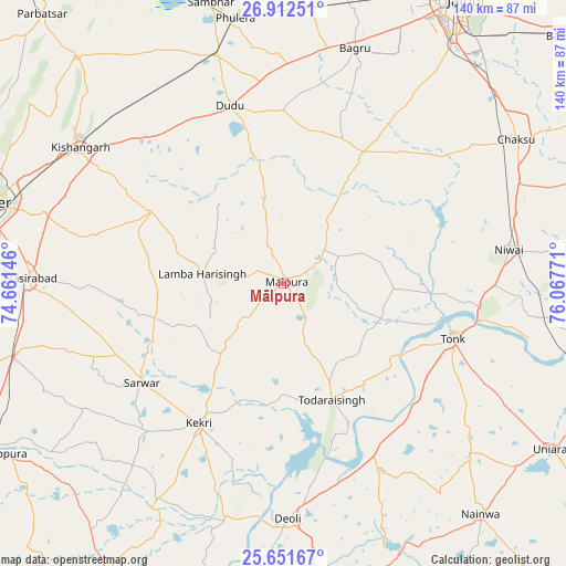
Mālpura GPS coordinates[2]
26° 17' 1.68" North, 75° 21' 52.488" East
| Map corner | latitude | longitude |
|---|---|---|
| Upper-left | 26.91251°, | 74.66146° |
| Center: | 26.2838°, | 75.36458° |
| Lower-right: | 25.65167°, | 76.06771° |
| Map W x H: | 140.2×140.2 km | = 87.1×87.1mi |
| max Lat: | 34.9274° ⇑27.1% North |
| Mālpura: | 26.2838° |
| min Lat: | ⇓72.9% South 8.09008° |
| min Long | Mālpura | max Long |
| 68.82655° | 75.36458° | 96.81° |
| W 20.5%⇐ | ⇒79.5% E |
Elevation
Elevation of Mālpura is 326 m = 1070 ft, and this is 30.4 m = 100 ft above average elevation for this country.
| Max E: |
3681 m = 12077 ft | 30.1% |
| Mālpura | 326 m 1070 ft | |
| Avg. | 295.6 m = 970 ft | |
Min E: |
1 m = 3 ft | 69.9% |
See also: India elevation on elevation.city.
Geographical zone
Mālpura is located in North temperate zone (between Tropic of Cancer and the Arctic Circle). Distance of this Northern Tropic circle is 316.6 km =196.7 mi to South.| Distance of | km | miles | from Mālpura |
|---|---|---|---|
| North Pole | 7084.6 | 4402.2 | to North |
| Arctic Circle | 4478.7 | 2782.9 | to North |
| Tropic Cancer | 316.6 | 196.7 | to South |
| Equator | 2922.5 | 1816 | to South |


Nearby cities:
15 places around Mālpura: (largest is in red/bold)
• Ajmer
74.7 km =46.4 mi,  284°
284°
• Chaksu
68.2 km =42.4 mi,  58°
58°
• Deoli
58.6 km =36.4 mi,  178°
178°
• Jahāzpur
74.3 km =46.2 mi,  186°
186°
• Kekri
40.8 km =25.4 mi,  211°
211°
• Kishangarh
61.2 km =38 mi,  303°
303°
• Naraina
58.5 km =36.4 mi,  344°
344°
• Nasīrābād
62.9 km =39.1 mi,  272°
272°
• Niwai
55.8 km =34.7 mi,  81°
81°
• Phulera
66.8 km =41.5 mi,  349°
349°
• Sarwār
43 km =26.7 mi,  235°
235°
• Sāmbhar
71.5 km =44.4 mi, 346°
• Todaraisingh
31.2 km =19.4 mi,  157°
157°
• Tonk
44.2 km =27.5 mi,  107°
107°
• Uniāra
20.8 km =12.9 mi,  225°
225°
Sources, notices
• [Note1] Compared only with cities in India existing in our database
• [Src1] Map data: © OpenStreetMap contributors (CC-BY-SA)
• [Src2] Other city data from geonames.org with taken over terms of usage.
• [Src3] Geographical zone / Annual Mean Temperature by Robert A. Rohde @ Wikipedia
