Uniāra geodata
Uniāra (Rajasthan) is a populated place; located in India in Asia/Kolkata (GMT+5.5) time zone. With population of 11,441 people, there are 2782 cities with bigger population in this country. Compared to other cities in India, 71.6% of cities are located further ↓South; 80.8% of cities are located further →East and 72.3% of cities have lower elevation than Uniāra. Note1


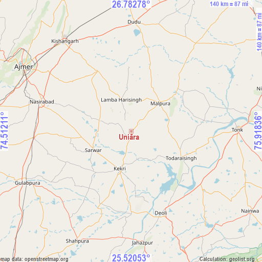
Uniāra GPS coordinates[2]
26° 9' 12.096" North, 75° 12' 54.828" East
| Map corner | latitude | longitude |
|---|---|---|
| Upper-left | 26.78278°, | 74.51211° |
| Center: | 26.15336°, | 75.21523° |
| Lower-right: | 25.52053°, | 75.91836° |
| Map W x H: | 140.3×140.4 km | = 87.2×87.2mi |
| max Lat: | 34.9274° ⇑28.4% North |
| Uniāra: | 26.15336° |
| min Lat: | ⇓71.6% South 8.09008° |
| min Long | Uniāra | max Long |
| 68.82655° | 75.21523° | 96.81° |
| W 19.2%⇐ | ⇒80.8% E |
Elevation
Elevation of Uniāra is 352 m = 1155 ft, and this is 56.4 m = 185 ft above average elevation for this country.
| Max E: |
3681 m = 12077 ft | 27.7% |
| Uniāra | 352 m 1155 ft | |
| Avg. | 295.6 m = 970 ft | |
Min E: |
1 m = 3 ft | 72.3% |
See also: India elevation on elevation.city.
Geographical zone
Uniāra is located in North temperate zone (between Tropic of Cancer and the Arctic Circle). Distance of this Northern Tropic circle is 302.1 km =187.7 mi to South.| Distance of | km | miles | from Uniāra |
|---|---|---|---|
| North Pole | 7099.1 | 4411.2 | to North |
| Arctic Circle | 4493.2 | 2791.9 | to North |
| Tropic Cancer | 302.1 | 187.7 | to South |
| Equator | 2908 | 1806.9 | to South |


Nearby cities:
15 places around Uniāra: (largest is in red/bold)
• Ajmer
66.4 km =41.3 mi,  300°
300°
• Deoli
47 km =29.2 mi,  159°
159°
• Gulābpura
62 km =38.5 mi,  243°
243°
• Jahāzpur
59.6 km =37 mi,  174°
174°
• Kekri
21.3 km =13.2 mi,  197°
197°
• Kishangarh
60.4 km =37.5 mi,  323°
323°
• Mālpura
20.8 km =12.9 mi,  45°
45°
• Naraina
70.9 km =44.1 mi,  359°
359°
• Nasīrābād
50.9 km =31.6 mi,  289°
289°
• Niwai
73.8 km =45.9 mi,  71°
71°
• Pushkar
76 km =47.2 mi, 299°
• Sarwār
22.7 km =14.1 mi, 243°
• Shāhpura
65.9 km =40.9 mi,  206°
206°
• Todaraisingh
30.3 km =18.8 mi,  118°
118°
• Tonk
57.2 km =35.5 mi,  88°
88°
Sources, notices
• [Note1] Compared only with cities in India existing in our database
• [Src1] Map data: © OpenStreetMap contributors (CC-BY-SA)
• [Src2] Other city data from geonames.org with taken over terms of usage.
• [Src3] Geographical zone / Annual Mean Temperature by Robert A. Rohde @ Wikipedia
