Niwai geodata
Niwai (Rajasthan) is a populated place; located in India in Asia/Kolkata (GMT+5.5) time zone. With population of 35,114 people, there are 1239 cities with bigger population in this country. Compared to other cities in India, 73.6% of cities are located further ↓South; 74.4% of cities are located further →East and 71.8% of cities have lower elevation than Niwai. Note1


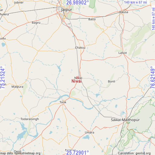
Niwai GPS coordinates[2]
26° 21' 38.628" North, 75° 55' 6.096" East
| Map corner | latitude | longitude |
|---|---|---|
| Upper-left | 26.98902°, | 75.21524° |
| Center: | 26.36073°, | 75.91836° |
| Lower-right: | 25.72901°, | 76.62149° |
| Map W x H: | 140.1×140.1 km | = 87.1×87.1mi |
| max Lat: | 34.9274° ⇑26.4% North |
| Niwai: | 26.36073° |
| min Lat: | ⇓73.6% South 8.09008° |
| min Long | Niwai | max Long |
| 68.82655° | 75.91836° | 96.81° |
| W 25.6%⇐ | ⇒74.4% E |
Elevation
Elevation of Niwai is 347 m = 1138 ft, and this is 51.4 m = 169 ft above average elevation for this country.
| Max E: |
3681 m = 12077 ft | 28.2% |
| Niwai | 347 m 1138 ft | |
| Avg. | 295.6 m = 970 ft | |
Min E: |
1 m = 3 ft | 71.8% |
See also: India elevation on elevation.city.
Geographical zone
Niwai is located in North temperate zone (between Tropic of Cancer and the Arctic Circle). Distance of this Northern Tropic circle is 325.1 km =202 mi to South.| Distance of | km | miles | from Niwai |
|---|---|---|---|
| North Pole | 7076 | 4396.8 | to North |
| Arctic Circle | 4470.1 | 2777.6 | to North |
| Tropic Cancer | 325.1 | 202 | to South |
| Equator | 2931 | 1821.2 | to South |


Nearby cities:
15 places around Niwai: (largest is in red/bold)
• Basi
53.9 km =33.5 mi,  13°
13°
• Chaksu
27.3 km =17 mi, 6°
• Dausa
72 km =44.7 mi,  35°
35°
• Deoli
86 km =53.4 mi,  218°
218°
• Gangāpur
80.5 km =50 mi,  81°
81°
• Jaipur
63.5 km =39.5 mi,  348°
348°
• Lākheri
80.8 km =50.2 mi,  161°
161°
• Lālsot
46.5 km =28.9 mi,  61°
61°
• Mālpura
55.8 km =34.7 mi,  261°
261°
• Nainwa
65.9 km =40.9 mi,  185°
185°
• Naraina
85.5 km =53.1 mi,  304°
304°
• Sawāi Mādhopur
56.7 km =35.2 mi,  131°
131°
• Todaraisingh
57.4 km =35.7 mi,  229°
229°
• Tonk
25.2 km =15.7 mi,  210°
210°
• Uniāra
73.8 km =45.9 mi,  251°
251°
Sources, notices
• [Note1] Compared only with cities in India existing in our database
• [Src1] Map data: © OpenStreetMap contributors (CC-BY-SA)
• [Src2] Other city data from geonames.org with taken over terms of usage.
• [Src3] Geographical zone / Annual Mean Temperature by Robert A. Rohde @ Wikipedia
