Nainwa geodata
Nainwa (Rajasthan) is a populated place; located in India in Asia/Kolkata (GMT+5.5) time zone. With population of 16,415 people, there are 2333 cities with bigger population in this country. Compared to other cities in India, 68.9% of cities are located further ↓South; 75.2% of cities are located further →East and 67% of cities have lower elevation than Nainwa. Note1


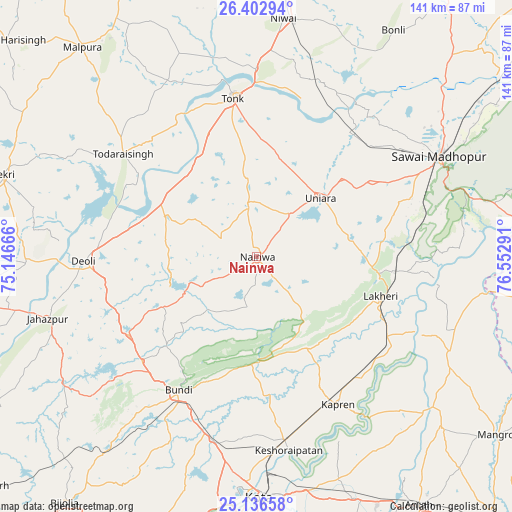
Nainwa GPS coordinates[2]
25° 46' 17.22" North, 75° 50' 59.208" East
| Map corner | latitude | longitude |
|---|---|---|
| Upper-left | 26.40294°, | 75.14666° |
| Center: | 25.77145°, | 75.84978° |
| Lower-right: | 25.13658°, | 76.55291° |
| Map W x H: | 140.8×140.8 km | = 87.5×87.5mi |
| max Lat: | 34.9274° ⇑31.1% North |
| Nainwa: | 25.77145° |
| min Lat: | ⇓68.9% South 8.09008° |
| min Long | Nainwa | max Long |
| 68.82655° | 75.84978° | 96.81° |
| W 24.8%⇐ | ⇒75.2% E |
Elevation
Elevation of Nainwa is 301 m = 988 ft, and this is 5.4 m = 18 ft above average elevation for this country.
| Max E: |
3681 m = 12077 ft | 33% |
| Nainwa | 301 m 988 ft | |
| Avg. | 295.6 m = 970 ft | |
Min E: |
1 m = 3 ft | 67% |
See also: India elevation on elevation.city.
Geographical zone
Nainwa is located in North temperate zone (between Tropic of Cancer and the Arctic Circle). Distance of this Northern Tropic circle is 259.6 km =161.3 mi to South.| Distance of | km | miles | from Nainwa |
|---|---|---|---|
| North Pole | 7141.5 | 4437.5 | to North |
| Arctic Circle | 4535.7 | 2818.4 | to North |
| Tropic Cancer | 259.6 | 161.3 | to South |
| Equator | 2865.5 | 1780.5 | to South |


Nearby cities:
15 places around Nainwa: (largest is in red/bold)
• Borkhera
34.9 km =21.7 mi,  217°
217°
• Būndi
42.7 km =26.5 mi,  209°
209°
• Deoli
47.1 km =29.3 mi,  268°
268°
• Jahāzpur
59.9 km =37.2 mi,  253°
253°
• Kekri
73.5 km =45.7 mi,  287°
287°
• Keshorai Pātan
54 km =33.6 mi,  170°
170°
• Kota
65.5 km =40.7 mi,  180°
180°
• Kāpren
46.5 km =28.9 mi,  151°
151°
• Lākheri
34.6 km =21.5 mi,  108°
108°
• Mālpura
74.8 km =46.5 mi,  319°
319°
• Niwai
65.9 km =40.9 mi,  5°
5°
• Sawāi Mādhopur
56.8 km =35.3 mi,  60°
60°
• Todaraisingh
46.3 km =28.8 mi,  307°
307°
• Tonk
44.3 km =27.5 mi,  352°
352°
• Uniāra
76.3 km =47.4 mi,  303°
303°
Sources, notices
• [Note1] Compared only with cities in India existing in our database
• [Src1] Map data: © OpenStreetMap contributors (CC-BY-SA)
• [Src2] Other city data from geonames.org with taken over terms of usage.
• [Src3] Geographical zone / Annual Mean Temperature by Robert A. Rohde @ Wikipedia
