Chaksu geodata
Chaksu (Rajasthan) is a populated place; located in India in Asia/Kolkata (GMT+5.5) time zone. With population of 33,098 people, there are 1316 cities with bigger population in this country. Compared to other cities in India, 75.5% of cities are located further ↓South; 74.1% of cities are located further →East and 67.3% of cities have lower elevation than Chaksu. Note1


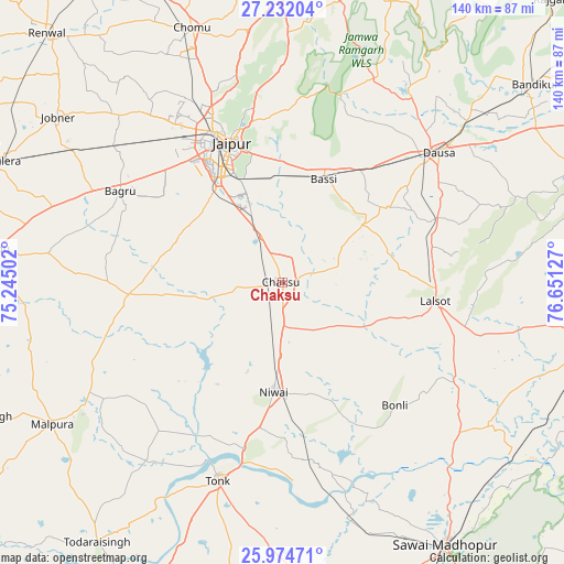
Chaksu GPS coordinates[2]
26° 36' 18.36" North, 75° 56' 53.304" East
| Map corner | latitude | longitude |
|---|---|---|
| Upper-left | 27.23204°, | 75.24502° |
| Center: | 26.6051°, | 75.94814° |
| Lower-right: | 25.97471°, | 76.65127° |
| Map W x H: | 139.8×139.8 km | = 86.9×86.9mi |
| max Lat: | 34.9274° ⇑24.5% North |
| Chaksu: | 26.6051° |
| min Lat: | ⇓75.5% South 8.09008° |
| min Long | Chaksu | max Long |
| 68.82655° | 75.94814° | 96.81° |
| W 25.9%⇐ | ⇒74.1% E |
Elevation
Elevation of Chaksu is 304 m = 997 ft, and this is 8.4 m = 28 ft above average elevation for this country.
| Max E: |
3681 m = 12077 ft | 32.7% |
| Chaksu | 304 m 997 ft | |
| Avg. | 295.6 m = 970 ft | |
Min E: |
1 m = 3 ft | 67.3% |
See also: India elevation on elevation.city.
Geographical zone
Chaksu is located in North temperate zone (between Tropic of Cancer and the Arctic Circle). Distance of this Northern Tropic circle is 352.3 km =218.9 mi to South.| Distance of | km | miles | from Chaksu |
|---|---|---|---|
| North Pole | 7048.9 | 4380 | to North |
| Arctic Circle | 4443 | 2760.8 | to North |
| Tropic Cancer | 352.3 | 218.9 | to South |
| Equator | 2958.2 | 1838.1 | to South |


Nearby cities:
15 places around Chaksu: (largest is in red/bold)
• Abhaneri
79.3 km =49.3 mi,  55°
55°
• Basi
27.1 km =16.8 mi,  21°
21°
• Bāndīkūi
79.4 km =49.3 mi,  51°
51°
• Dausa
49.9 km =31 mi, 50°
• Gangāpur
77.9 km =48.4 mi,  100°
100°
• Jaipur
38.4 km =23.9 mi,  335°
335°
• Jobner
69 km =42.9 mi,  306°
306°
• Lālsot
38.2 km =23.7 mi, 97°
• Manoharpur
77 km =47.8 mi,  0°
0°
• Mālpura
68.2 km =42.4 mi,  238°
238°
• Naraina
76.5 km =47.5 mi,  285°
285°
• Niwai
27.3 km =17 mi,  186°
186°
• Phulera
76.3 km =47.4 mi, 293°
• Sawāi Mādhopur
75.8 km =47.1 mi,  148°
148°
• Tonk
51.3 km =31.9 mi,  198°
198°
Sources, notices
• [Note1] Compared only with cities in India existing in our database
• [Src1] Map data: © OpenStreetMap contributors (CC-BY-SA)
• [Src2] Other city data from geonames.org with taken over terms of usage.
• [Src3] Geographical zone / Annual Mean Temperature by Robert A. Rohde @ Wikipedia
