Todaraisingh geodata
Todaraisingh (Rajasthan) is a populated place; located in India in Asia/Kolkata (GMT+5.5) time zone. With population of 22,613 people, there are 1865 cities with bigger population in this country. Compared to other cities in India, 70.5% of cities are located further ↓South; 78.7% of cities are located further →East and 71.7% of cities have lower elevation than Todaraisingh. Note1


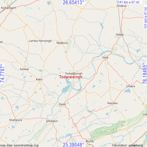
Todaraisingh GPS coordinates[2]
26° 1' 26.436" North, 75° 28' 54.552" East
| Map corner | latitude | longitude |
|---|---|---|
| Upper-left | 26.65413°, | 74.7787° |
| Center: | 26.02401°, | 75.48182° |
| Lower-right: | 25.39048°, | 76.18495° |
| Map W x H: | 140.5×140.5 km | = 87.3×87.3mi |
| max Lat: | 34.9274° ⇑29.5% North |
| Todaraisingh: | 26.02401° |
| min Lat: | ⇓70.5% South 8.09008° |
| min Long | Todaraisingh | max Long |
| 68.82655° | 75.48182° | 96.81° |
| W 21.3%⇐ | ⇒78.7% E |
Elevation
Elevation of Todaraisingh is 345 m = 1132 ft, and this is 49.4 m = 162 ft above average elevation for this country.
| Max E: |
3681 m = 12077 ft | 28.3% |
| Todaraisingh | 345 m 1132 ft | |
| Avg. | 295.6 m = 970 ft | |
Min E: |
1 m = 3 ft | 71.7% |
See also: India elevation on elevation.city.
Geographical zone
Todaraisingh is located in North temperate zone (between Tropic of Cancer and the Arctic Circle). Distance of this Northern Tropic circle is 287.7 km =178.8 mi to South.| Distance of | km | miles | from Todaraisingh |
|---|---|---|---|
| North Pole | 7113.5 | 4420.1 | to North |
| Arctic Circle | 4507.6 | 2800.9 | to North |
| Tropic Cancer | 287.7 | 178.8 | to South |
| Equator | 2893.6 | 1798 | to South |


Nearby cities:
15 places around Todaraisingh: (largest is in red/bold)
• Borkhera
58.1 km =36.1 mi,  164°
164°
• Būndi
66.9 km =41.6 mi,  166°
166°
• Chaksu
79.6 km =49.5 mi,  35°
35°
• Deoli
31.4 km =19.5 mi,  198°
198°
• Jahāzpur
49.4 km =30.7 mi, 204°
• Kekri
33.7 km =20.9 mi,  259°
259°
• Lākheri
79.8 km =49.6 mi,  119°
119°
• Mālpura
31.2 km =19.4 mi,  337°
337°
• Nainwa
46.3 km =28.8 mi,  127°
127°
• Nasīrābād
80.9 km =50.3 mi,  292°
292°
• Niwai
57.4 km =35.7 mi,  49°
49°
• Sarwār
47.2 km =29.3 mi,  275°
275°
• Shāhpura
71.5 km =44.4 mi,  231°
231°
• Tonk
34.5 km =21.4 mi,  62°
62°
• Uniāra
30.3 km =18.8 mi,  298°
298°
Sources, notices
• [Note1] Compared only with cities in India existing in our database
• [Src1] Map data: © OpenStreetMap contributors (CC-BY-SA)
• [Src2] Other city data from geonames.org with taken over terms of usage.
• [Src3] Geographical zone / Annual Mean Temperature by Robert A. Rohde @ Wikipedia
