Lākheri geodata
Lākheri (Rajasthan) is a populated place; located in India in Asia/Kolkata (GMT+5.5) time zone. With population of 28,463 people, there are 1514 cities with bigger population in this country. Compared to other cities in India, 68.3% of cities are located further ↓South; 71.9% of cities are located further →East and 57.4% of cities have lower elevation than Lākheri. Note1


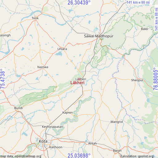
Lākheri GPS coordinates[2]
25° 40' 20.532" North, 76° 10' 36.912" East
| Map corner | latitude | longitude |
|---|---|---|
| Upper-left | 26.30439°, | 75.4738° |
| Center: | 25.67237°, | 76.17692° |
| Lower-right: | 25.03698°, | 76.88005° |
| Map W x H: | 140.9×140.9 km | = 87.6×87.6mi |
| max Lat: | 34.9274° ⇑31.7% North |
| Lākheri: | 25.67237° |
| min Lat: | ⇓68.3% South 8.09008° |
| min Long | Lākheri | max Long |
| 68.82655° | 76.17692° | 96.81° |
| W 28.1%⇐ | ⇒71.9% E |
Elevation
Elevation of Lākheri is 237 m = 778 ft, and this is 58.6 m = 192 ft below average elevation for this country.
| Max E: |
3681 m = 12077 ft | 42.6% |
| Avg. | 295.6 m = 970 ft | |
| Lākheri | 237 m = 778 ft | |
Min E: |
1 m = 3 ft | 57.4% |
See also: India elevation on elevation.city.
Geographical zone
Lākheri is located in North temperate zone (between Tropic of Cancer and the Arctic Circle). Distance of this Northern Tropic circle is 248.6 km =154.5 mi to South.| Distance of | km | miles | from Lākheri |
|---|---|---|---|
| North Pole | 7152.6 | 4444.4 | to North |
| Arctic Circle | 4546.7 | 2825.2 | to North |
| Tropic Cancer | 248.6 | 154.5 | to South |
| Equator | 2854.5 | 1773.7 | to South |


Nearby cities:
15 places around Lākheri: (largest is in red/bold)
• Anta
59.4 km =36.9 mi,  167°
167°
• Borkhera
56.4 km =35 mi,  252°
252°
• Bārān
72.2 km =44.9 mi,  151°
151°
• Būndi
60 km =37.3 mi,  244°
244°
• Deoli
80.4 km =50 mi,  276°
276°
• Keshorai Pātan
48.5 km =30.1 mi,  209°
209°
• Kota
64.2 km =39.9 mi, 211°
• Kāpren
31.4 km =19.5 mi,  199°
199°
• Māngrol
50.6 km =31.4 mi,  138°
138°
• Nainwa
34.6 km =21.5 mi,  288°
288°
• Niwai
80.8 km =50.2 mi,  341°
341°
• Sawāi Mādhopur
42.4 km =26.3 mi,  23°
23°
• Sheopur
52 km =32.3 mi,  90°
90°
• Todaraisingh
79.8 km =49.6 mi,  299°
299°
• Tonk
67.3 km =41.8 mi,  324°
324°
Sources, notices
• [Note1] Compared only with cities in India existing in our database
• [Src1] Map data: © OpenStreetMap contributors (CC-BY-SA)
• [Src2] Other city data from geonames.org with taken over terms of usage.
• [Src3] Geographical zone / Annual Mean Temperature by Robert A. Rohde @ Wikipedia
