Sonari geodata
Sonari (Assam) is a seat of a second-order administrative division; located in India in Asia/Kolkata (GMT+5.5) time zone. In our database, there are 3475 cities with bigger population. Compared to other cities in India, 79% of cities are located further ↓South; 99.5% of cities are located further ←West and 69.1% of cities have higher elevation than Sonari. Note1


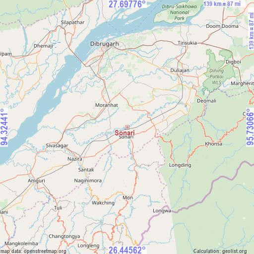
Sonari GPS coordinates[2]
27° 4' 24.384" North, 95° 1' 39.108" East
| Map corner | latitude | longitude |
|---|---|---|
| Upper-left | 27.69776°, | 94.32441° |
| Center: | 27.07344°, | 95.02753° |
| Lower-right: | 26.44562°, | 95.73066° |
| Map W x H: | 139.2×139.2 km | = 86.5×86.5mi |
| max Lat: | 34.9274° ⇑21% North |
| Sonari: | 27.07344° |
| min Lat: | ⇓79% South 8.09008° |
| min Long | Sonari | max Long |
| 68.82655° | 95.02753° | 96.81° |
| W 99.5%⇐ | ⇒0.5% E |
Elevation
Elevation of Sonari is 97 m = 318 ft, and this is 198.6 m = 652 ft below average elevation for this country.
| Max E: |
3681 m = 12077 ft | 69.1% |
| Avg. | 295.6 m = 970 ft | |
| Sonari | 97 m = 318 ft | |
Min E: |
1 m = 3 ft | 30.9% |
See also: India elevation on elevation.city.
Geographical zone
Sonari is located in North temperate zone (between Tropic of Cancer and the Arctic Circle). Distance of this Northern Tropic circle is 404.4 km =251.3 mi to South.| Distance of | km | miles | from Sonari |
|---|---|---|---|
| North Pole | 6996.8 | 4347.6 | to North |
| Arctic Circle | 4390.9 | 2728.4 | to North |
| Tropic Cancer | 404.4 | 251.3 | to South |
| Equator | 3010.3 | 1870.5 | to South |


Nearby cities:
15 places around Sonari: (largest is in red/bold)
• Amguri
57.4 km =35.7 mi,  239°
239°
• Chābua
47.7 km =29.6 mi,  17°
17°
• Dhemāji
63.3 km =39.3 mi,  316°
316°
• Dibrugarh
46.7 km =29 mi,  345°
345°
• Duliāgaon
43.2 km =26.8 mi,  39°
39°
• Khonsa
53.8 km =33.4 mi,  96°
96°
• Mon
37.7 km =23.4 mi,  175°
175°
• Morānha
16.8 km =10.4 mi, 318°
• Mākum
61.2 km =38 mi, 41°
• Nahorkatiya
39.3 km =24.4 mi,  52°
52°
• Nāmrup
31.8 km =19.8 mi,  65°
65°
• Nāzirā
33.7 km =20.9 mi, 238°
• Sibsāgar
39.9 km =24.8 mi,  255°
255°
• Sonāri
5.5 km =3.4 mi,  191°
191°
• Tinsukia
56.7 km =35.2 mi, 35°
Sources, notices
• [Note1] Compared only with cities in India existing in our database
• [Src1] Map data: © OpenStreetMap contributors (CC-BY-SA)
• [Src2] Other city data from geonames.org with taken over terms of usage.
• [Src3] Geographical zone / Annual Mean Temperature by Robert A. Rohde @ Wikipedia
