Sonāri geodata
Sonāri (Assam) is a populated place; located in India in Asia/Kolkata (GMT+5.5) time zone. With population of 19,672 people, there are 2066 cities with bigger population in this country. Compared to other cities in India, 78.5% of cities are located further ↓South; 99.5% of cities are located further ←West and 67.2% of cities have higher elevation than Sonāri. Note1


Sonāri GPS coordinates[2]
27° 1' 28.632" North, 95° 0' 58.644" East
| Map corner | latitude | longitude |
|---|---|---|
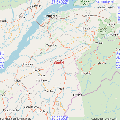
| Upper-left | 27.64922°, | 94.31317° |
| Center: | 27.02462°, | 95.01629° |
| Lower-right: | 26.39653°, | 95.71942° |
| Map W x H: | 139.3×139.3 km | = 86.6×86.6mi |
| max Lat: | 34.9274° ⇑21.5% North |
| Sonāri: | 27.02462° |
| min Lat: | ⇓78.5% South 8.09008° |
| min Long | Sonāri | max Long |
| 68.82655° | 95.01629° | 96.81° |
| W 99.5%⇐ | ⇒0.5% E |
Elevation
Elevation of Sonāri is 106 m = 348 ft, and this is 189.6 m = 622 ft below average elevation for this country.
| Max E: |
3681 m = 12077 ft | 67.2% |
| Avg. | 295.6 m = 970 ft | |
| Sonāri | 106 m = 348 ft | |
Min E: |
1 m = 3 ft | 32.8% |
See also: India elevation on elevation.city.
Geographical zone
Sonāri is located in North temperate zone (between Tropic of Cancer and the Arctic Circle). Distance of this Northern Tropic circle is 398.9 km =247.9 mi to South.| Distance of | km | miles | from Sonāri |
|---|---|---|---|
| North Pole | 7002.2 | 4351 | to North |
| Arctic Circle | 4396.3 | 2731.7 | to North |
| Tropic Cancer | 398.9 | 247.9 | to South |
| Equator | 3004.9 | 1867.2 | to South |


Nearby cities:
15 places around Sonāri: (largest is in red/bold)
• Amguri
53.9 km =33.5 mi,  244°
244°
• Chābua
53.3 km =33.1 mi,  17°
17°
• Dibrugarh
51.7 km =32.1 mi,  348°
348°
• Duliāgaon
48.2 km =30 mi,  36°
36°
• Khonsa
54.5 km =33.9 mi,  90°
90°
• Longleng
62.6 km =38.9 mi,  198°
198°
• Mon
32.4 km =20.1 mi,  172°
172°
• Morānha
20.7 km =12.9 mi,  331°
331°
• Mākum
66 km =41 mi, 38°
• Nahorkatiya
43.6 km =27.1 mi,  47°
47°
• Nāmrup
35.4 km =22 mi,  57°
57°
• Nāzirā
30.3 km =18.8 mi,  246°
246°
• Sibsāgar
37.8 km =23.5 mi,  263°
263°
• Sonari
5.5 km =3.4 mi,  11°
11°
• Tinsukia
61.8 km =38.4 mi,  33°
33°
Sources, notices
• [Note1] Compared only with cities in India existing in our database
• [Src1] Map data: © OpenStreetMap contributors (CC-BY-SA)
• [Src2] Other city data from geonames.org with taken over terms of usage.
• [Src3] Geographical zone / Annual Mean Temperature by Robert A. Rohde @ Wikipedia
